Grain-size of beach sediments and their interactions with wave climate are crucial for modeling cross-shore and longshore sediment-transport processes and the evolution of beach morphology. Although recent studies have emphasized the temporal and spatial variability of beach sediments, these dynamics have been mostly studied in uncliffed coasts. Thus, the spatial and temporal dynamics of beach sediments along cliff-dominated coastlines remain as one of the least constrained aspects of coastal sediment dynamics. Here, we quantify the temporal dynamics of sediment along cliff-dominated beaches in the Sharon Escarpment, the Eastern Mediterranean coast of Israel, based on repeated, seasonal-scale sampling of surficial sediments along two transects, over three years. Total of 104 samples were collected and analyzed for particle size distribution. We found a general periodicity in the beach grain size: winter/spring cliff erosion associated with intense wave storms contributes eolianite clasts (very coarse sand 1-2 mm) and quartz (fine sand 180-220 mu m) to the beach. During storms with significant waves >4m, beach sediments are transported northwards alongshore, and deposited all over the beach as the storm ceases. After being deposited, the surficial sediments become finer with time due to the gradual burial of the beach by wind-transported fine sand. Eolian abrasion might also contribute to the observed seasonal finning pattern of the beach sediments by disintegrating eolianite clasts. We stress that cliff erosion, waves and wind control seasonal changes in particle size distribution of sediment along cliff-dominated beaches.
Retrogressive submarine landslide complexes are abundant on global margins, characterized by stepping head scarp bathymetric morphology. Investigation of major complexes showed they evolved through sequential up-dip migrating collapse on a single basal failure. Here, we explore the Owl slide complex, a relatively small scar on the southeastern Mediterranean margin. Sub-meter resolution seismic-reflection profiles and 5-m resolution bathymetry reveal that the Owl comprises a primary scar (similar to 1.7 km(2)), two secondary scars 500 m upslope of the primary scar, and additional scars along the lateral margins. The complex comprises six vertically-stacked chaotic mass transport deposit lobes, interbedded with intervals of continuous reflections, representing gradual sediment accumulation. Distinct basal surfaces of each lobe connect with its respective head scarp in an upward retrogressive pattern. Underlying the complex is a prominent unconformity correlating with the last glacial transgression. Four faults beneath the unconformity create stepped geometry reflected in the bathymetry. We suggest that the Owl complex was formed through a multistage retrogressive sequence of 4 to 6-failure events (similar to 16,000 BP- similar to 1000 BP), with an average recurrence interval of similar to 3000 years and intermittent periods of quiescence lasting thousands of years. Over-steepening of the head scarp by each event pre-conditioned subsequent failures. However, additional sediment accumulation of several meters was necessary before another failure could occur. Over time, consecutive retrogressive events show a linear decrease in volume, ultimately stabilizing the slope. The phased collapse mechanism described here forms the typical retrogressive sliding morphology but has different geohazard implications than the single basal failure mechanism.
Marine continental shelf sediments with high deposition rates may provide useful archives of rapid geomagnetic secular variation as long as the primary magnetization is not altered substantially by diagenesis. To quantify the effects of sulfate (SO42-) reduction, which is a dominant early diagenetic process in such sediments, on paleomagnetic recording, we analyzed four 6-m long sediment cores from the eastern Mediterranean shelf. Two cores did not reach the methanogenic zone and are characterized by continuous organoclastic sulfate reduction (OSR), while the other two have a distinctive shallow sulfate-methane transition zone (SMTZ). Age models based on 28 radiocarbon ages indicate steady deposition rates with spatially varying age spans, which suggest that different parts of the shelf stopped accumulating sediments at different times during the Holocene. The upper sediment column in all cores is dominated by detrital titanomagnetite and biogenic magnetite. OSR-affected sediments record continuous (titano) magnetite dissolution, which resulted in steady magnetic susceptibility and remanence decreases. For cores that reach the methanogenic zone, similar behavior is observed at or above the STMZ, but magnetic properties stabilize at greater depths. Paleomagnetic directions in these sediments are more coherent, with better agreement with geomagnetic models than sediments affected by OSR. We suggest that methane-rich sediments with a shallow SMTZ and high sedimentation rates can better preserve primary paleomagnetic signals than OSR-dominated sediments due to a lack of dissolved sulfide in the main methanogenic zone, and that a susceptibility decline with depth should be a warning sign for paleomagnetic studies.
AbstractThe detachment (i.e., break‐off) of down‐going subducting oceanic slabs is a major geodynamic event with far‐reaching consequences, one of which is the reduction of the slab pull force acting on the trailing plate. We investigate the motion of the Sinai Microplate where a recent (∼1 Myr ago) slab break‐off occurred along its sole converging plate boundary (Cyprian Arc) with the overriding Anatolia Microplate. Based on new bathymetric mapping, high‐resolution seismic reflection imaging, geodetic and earthquake data, we show that Sinai is actively moving in a northwest direction with respect to Nubia. Our results indicate that despite the recent slab break‐off, Sinai has and is still being pulled (or pushed) toward the overriding Anatolia Microplate. The continued convergence possibly occurs because of a persistent slab pull force, a suction force induced by the down‐going detached slab and/or by the upper mantle flow induced by the Afar Plume.
Pockmarks are morphological depressions commonly observed in ocean and lake floors. Pockmarks form by fluid (typically gas) seepage thorough a sealing sedimentary layer, deforming and breaching the layer. The seepage-induced sediment deformation mechanisms, and their links to the resulting pockmarks morphology, are not well understood. To bridge this gap, we conduct laboratory experiments in which gas seeps through a granular (sand) reservoir, overlaid by a (clay) seal, both submerged under water. We find that gas rises through the reservoir and accumulates at the seal base. Once sufficient gas over-pressure is achieved, gas deforms the seal, and finally escapes via either: (i) doming of the seal followed by dome breaching via fracturing; (ii) brittle faulting, delineating a plug. The gas lifts the plug and seeps through the bounding faults; or (iii) plastic deformation by bubbles ascending through the seal. The preferred mechanism is found to depend on the seal thickness and stiffness: in stiff seals, a transition from doming and fracturing to brittle faulting occurs as the thickness increases, whereas bubbles rise is preferred in the most compliant, thickest seals. Seepage can also occur by mixed modes, such as bubbles rising in faults. Repeated seepage events suspend the sediment at the surface and create pockmarks. We present a quantitative analysis that explains the tendency for the various modes of deformation observed experimentally. Finally, we connect simple theoretical arguments with field observations, highlighting similarities and differences that bound the applicability of laboratory experiments to natural pockmarks.
Submarine canyons serve as important sediment transport conduits from littoral zones to the deep sea, with strong impacts on the sedimentation patterns in marginal areas of the ocean. Here, we present a study of the geological history and the recent activity of the Nahariya submarine canyon, the longest of a system of ~15 small blind canyons located in the eastern Mediterranean Sea, offshore Israel. Two piston cores retrieved from the middle and outlet of the canyon, at 650 m and 915 m water depth, respectively, were the focus of a multi-proxy study aiming to characterize sediment transport and deposition along the canyon during the Last Glacial and up to the present. Both cores reveal a sequence of homogenous sediment of late last glacial age, which are capped by an unconformity overlying by fine laminated sediment dated to the last ~200 years. Thus, the deglacial and most of the Holocene intervals are absent from the record. Evidence for down canyon sediment transport are abundant and include a 70 cm interval of mud clasts with disordered glacial ages that appears immediately below the hiatus, as well as broken calcareous shells of dead benthic foraminiferal species of shallow marine habitats, which are abundant throughout both cores. Similarly, shelf-derived living benthic foraminiferal species were found in the core-tops, indicating that active sediment transport persists along this canyon today. We conclude that the history of Nahariya submarine canyon includes a period of sediment accumulation that lasted until the last deglaciation. Thereafter, the canyon was dominated by an erosive regime that persisted throughout the Holocene. Sediment accumulation resumed ~200 years ago. We suggest that the recent resumption of sediment-accumulation is a result of anthropogenic amplification of on-land soil erosion accompanied by a wet period that persisted in the region and enhanced land to sea sediment transport.
Landslides are widely recognized as key components of landscape evolution in areas of steep topography. Here, we present a new framework for examining landslide inventories in the context of the volume-based impact that different landslide sizes have on shaping the landscape, that is, their geomorphic effectiveness (GE). Focusing on an actively retreating coastal cliff in the Eastern Mediterranean and utilizing a LiDAR-derived inventory of over 1,100 cliff landslides that occurred between 2014 and 2019, we show that segments of the cliff are characterized by two principal types of GE distributions: (a) A "humped" GE distribution where the accumulated erosion volume of the largest and rarest collapses in the inventory is similar or lower than that of more frequent, mid-range collapses and (b) Nearly monotonically increasing GE distribution where the cumulative volume of larger collapses consistently surpasses that of smaller magnitude collapses. Regardless of the GE distribution type, we found that the cumulative geomorphic impact of the small and most probable collapses was negligible. Extending this new GE framework to 9 other previously published landslide inventories (coastal and mountainous), we demonstrate that precipitation and seepage-induced landslide inventories are commonly characterized by monotonic-type GE distributions, dominated by large landslides (>10(-1) of the volume of the largest landslide), and that hump-shaped GE distributions, dominated by more frequent mid-size landslides, commonly occur under "dry" triggers (e.g., earthquakes). We propose that the humped GE distribution could reflect the lack of deep mechanical weakening, which exerts a higher probability of the largest landslides in the inventories triggered by "wet" factor.
Crustal deformation and seismicity in the Levant region are mainly related to the plate-boundary Dead Sea Fault (DSF) and the intraplate Carmel−Gilboa−Faria Fault System (CGFS). The intersection between these two major fault systems is generally treated as a ∼35-km-wide deformation belt stretched between the Faria and Gilboa Faults. Here, we present spatial and temporal analysis of faulting near this intersection. Our analysis is based on new geological mapping, new high-resolution airborne light detection and ranging (LiDAR) data, and seismic reflection profiles and indicates northward migration and localization of the intersection over time since the early Miocene. We discovered and mapped outcrops of Miocene, Pliocene, and Pleistocene rock units as well as faults and reconstructed the evolution of deformation. Three main tectonic phases were identified in this area covering the following periods: the early−middle Miocene, the late Miocene−Pliocene, and the Quaternary. During the first phase, the DSF and the CGFS developed, and the CGFS faulted along a series of subparallel grabens and elongated NW−SE, between the southernmost Faria and the northernmost Gilboa faults, over a belt width of ∼35 km. During the second phase, deformation along the CGFS migrated northward and concentrated at an ∼6-km-wide zone in the northern Faria Anticline. During the third stage, small-scale northward migration and localization of the deformation to a width zone of ∼1−2 km at the southern boundary of the Beit She’an Valley occurred. Faults from the third phase reveal both sinistral and normal faulting. We propose that the currently active intersection between the DSF and the CGFS is located east of this localized deformation zone, near a right step of the DSF and the uplifted area of Tel Al-Qarn in the eastern Jordan Valley. We suggest that the northward migration and localization of this intersection are related to regional tectonic changes, spatial variations in the Sinai-Arabia Euler pole, and the localization of deformation along the DSF.
Magnetic properties of marine sediments are dictated not only by the detrital mineralogy, but also by diagenetic processes that can start instantaneously after deposition and may proceed for a long time as sediments are buried. Early diagenesis encompass a range of biochemical reactions associated with bacterial respirations. These may include oxidation at the water sediment interface, iron reduction, sulfate reduction, and anaerobic oxidation of methane (AOM) if methane is present. To investigate the link between diagenesis, sedimentary magnetic properties and quality of paleomagnetic recording, we collected eight 6m-long piston-cores from the Holocene Eastern Mediterranean continental shelf in four locations. Two locations are characterized by high concentration of methane and detectable sulfate-methane transition zone (SMTZ) at depth of 1-4 m. In the other two locations, organoclastic sulfate reduction is dominant throughout the entire cores. Sedimentation rates in this region range between 1 - 5 mm/year. In all cores, concentrations of sulfate, methane and ferrous iron were measured from the pore water. The geochemical data were compared to the mineral magnetic profile that include a range of parameters calculated from IRM, ARM, low- and high- field susceptibility, hysteresis, and FORCs. Paleomagnetic time-series of declination and inclination were obtained from demagnetization experiments carried out in 2 cm resolution. Age models were constructed from radiocarbon dating of carefully collected foraminifera. The results show a consistent link between the diagenetic zones and the magnetic mineralogy: Increase of magnetic properties in the shallow ferruginous zone, decay of magnetic parameters in the sulfate reduction zones, rapid decrease at the SMTZ and stabilization at the methanogenic zone. XHR-SEM analysis show multiple generations of greigite and pyrite framboids at all depths and unaltered detrital titanomagnetites. We find that except a short time interval below the SMTZ of one core, the paleomagnetic directions in these sediments do not represent the expected directions of the geomagnetic field. We conclude that continuous organoclastic sulfate reduction in marine sediments might have a profound effect on the quality of paleomagnetic recording, but AOM at the SMTZ may help stabilize the magnetic phase.
Mass movements along coasts is a complex process that reflects interactions of coastal sediments and hydrodynamics. To capture the essentials of this process, the sediment budget of cliff-dominated beaches in the eastern Mediterranean was quantified using repeat ground-based LiDAR scans and time-lapse photography at storm to seasonal time-scales over a 3-year period. Observations revealed that while the overall sediment-budget was slightly positive, the seasonal and storm-scale volumetric changes along the studied beaches alternated between net erosion and net accretion at similar volumes. This implies that the current state of the coastal sediment budget along the studied beaches is dynamically sustained.
Nile derived siliciclastic sediments are the main source of sedimentation along the Levant continental margins of the Mediterranean Sea. These sediments are transported along the southeastern Mediterranean coast via well-documented longshore currents, mainly operating along the shelf. However, the cross shelf component of sediment transport, responsible for conveying sediments toward the upper slope, is less known. To better understand the cross-shelf vs. the longshore component of sediment transport we studied a ~6 m long piston core (DOR280) sampled on the upper continental slope (280 m water depth) and analyzed benthic foraminiferal assemblages and their shell taphonomy alongside the particle size distribution and mineralogy of bulk sediments, to document both the source and the transport mechanism of those upper continental-slope sediments. The radiocarbon dating at the core-base is ~650 Cal. Yrs BP, indicating an exceptionally high average sedimentation rate of ~800 cm/kyr. DOR280 consists of two alternating distinct sedimentary facies: (1) laminated (L) intervals up to ~40 cm thick each and showing a high ratio of allochthonous vs. autochthonous (allo/auto) benthic foraminiferal species and a high percentage of broken shells, indicating contribution of transported sediments originating from mid-shelf habitats; (2) non-laminated (NL) intervals up to ~200 cm thick each and showing a low allo/auto ratio and low percentages of broken shells, indicating mostly in-situ hemipelagic deposition. The L intervals are interpreted here as turbidites. The sedimentation rates calculated only for the NL intervals are still exceptionally high, thus excluding hemipelagic sedimentation as the sole mechanism for the NL deposition. Therefore, a contour bottom current transported component is suggested here as a source of the NL sedimentation. We conclude that a mixed contourite-turbidite system actively prevails along the upper continental slope of the Levant coast, offshore Israel. The mid-shelf to upper slope sediment transport is nearly continuous and presents occasional turbidite events of average decadal reoccurrence time.
Nile derived siliciclastic sediments are the main source for sedimentation along the Levant continental margins. The sediments are transported along the southeastern Mediterranean coast via jet and longshore currents, mainly operating along the shelf. However, the cross shelf component of sediments transport, responsible for conveying sediments towards the upper slope, is less known. To better understand the cross-shelf vs. the longshore components of sediment transport, we studied two ~5.5 m piston cores: DOR280 and DOR350, sampled on the upper continental slope at 280 m and 350 m water depth, respectively. We analyzed the particle size distribution (PSD) as well as the benthic-foraminiferal assemblages and their shells taphonomy, for documenting both the source and the transport mechanism of the upper continental-slope sediments. The radiocarbon sediment age at the DOR280 core-base is ~660 ±70 Cal Yrs. B.P., indicating an exceptionally high average sedimentation rate of ~800 cm/kyr. DOR280 consists of alternating two sedimentary facies: (1) Laminated (L) intervals with bimodal PSD and high ratio of allochthonous vs. autochthonous (allo/auto) foraminiferal species, characterized by a high percentage of benthic-foraminiferal broken and poorly preserved shells, indicating contribution of transported sediments originating from mid-shelf habitats. (2) Non-laminated (NL) intervals with unimodal PSD, low allo/auto ratio (<1) and low percentage of broken shells, indicating mostly in-situ deposition. The L intervals are interpreted as sediment laden gravity currents, possibly turbidites. Numerous centimeters-thick turbiditic events were identified, based on grain-size grading and discontinuous eroded lower stratigraphic-contacts. Sedimentation rate calculated only for the NL intervals is still exceptionally high, excluding hemipelagic sedimentation as the sole deposition. Thus, a contour bottom-current transported component is suggested for the NL sediments of DOR280 (i.e. contourites). DOR350 reveals higher sedimentation rates (age of ~350 ±80 Cal Yrs. B.P. at the core-base) and consists mostly of the L facies. Hence, the sediments of DOR350 are mostly consist of transported (by turbidities) sediments with only minor contribution of hemipelagic sedimentation or contourites. We conclude that a hybrid contourite-turbidite system actively prevails along the Levant upper continental slope offshore Israel, apparently at water depth of less than 350 m.
The tectonic nature of the Sinai Microplate's western boundary is clouded with uncertainties. Early studies suggested that the western edge of Sinai is fully connected to the African Plate, thus concluding that Sinai is a sub-plate. Later, bathymetric analyses of prominent lineated faults straddling across the western edge of the Levant Basin have suggested that, in fact, this area is a plate boundary that accommodates dextral motion between the African Plate and the Sinai Microplate. However, this inference contradicts geological and geophysical observations across the Gulf of Suez, the southern continuation of the same plate boundary. Here we present preliminary results from a recent geophysical cruise aboard the R/V Bat Galim. We focused our investigation on one of the major faults, oriented in an NW-SE direction (located ~80 km southwest of the Eratosthenes Seamount), creating the plate boundary. We collected high-resolution shallow multichannel seismic reflection data complemented with multibeam bathymetry data. We also acquired two piston cores near the trace of the fault. These observations unravel the shallow three-dimensional structure of the fault system whereby several curved and steeply dipping normal fault segments are splayed from the main fault trace in a westerly direction. These secondary faults display a back-tilted and step-like morphology. This structure is best explained by a sinistral motion acting along the master fault. Independently, we present an updated Africa-Sinai Euler pole based on the motion of GPS stations recorded between 1996 and 2019. The results suggest that Sinai is moving in a northwesterly direction with respect to Africa (1.7-1.9±0.9 mm/yr). Focal mechanism solutions calculated for recent earthquakes occurring in this region (Mw>4.5) agree with the geodetic constraints of a sinistral relative motion. Overall, these observations suggest that the western boundary of Sinai has been, and still is, accommodated sinistral motion relative to Africa. This conclusion implies that the Sinai Microplate is moving faster with respect to Eurasia relative to the motion of Africa with respect to Eurasia. This, in turn, seems to be in conflict with the notion that subduction of the oceanic lithosphere north of the Sinai Microplate (i.e., east of Cyprus) has recently ceased. We speculate that the downgoing slab might still promote the relatively fast northward motion of Sinai and/or a northward drag force induced by large-scale mantle flow related to the Afar plume could also contribute to the motion of the Sinai Microplate.
The Eastern Alps are an important tourist destination and attract many visitors every year for their scenic beauty, sports attractions and rich cultural heritage. Tourism is an important source of income and contributes to the revival or maintenance of local traditions. However, tourism also has potential negative impacts on the regions, for example Austria's largest forest fire in Hirschwang near Reichenau an der Rax (district of Neunkirchen) in the period 25.10.2021 to 6.11.2021 was anthropogenically triggered by tourists. In addition to the anthropogenic factors, the increase in extreme weather events caused by climate change and its scale dependent variations are a major challenge in the preparation of wildfire risk maps. Wildfires in steep Alpine valleys behave differently than those on flat or moderate inclined slopes. The present work describes a wildfire that occurred in August 2018 in a famous world-heritage site in Austria (Melzner et al. 2019), which was presumably initiated by a carelessly discarded cigarette or the reflection of a broken glass bottle at the foot of the rockwall. Indicators of fire severity and rockfall occurrence during and after the fire are described. The vertical rockwalls, the anabatic winds and patchy vegetation pattern, caused an upward jumping of the fire resulting in a spotty fire pattern. This most probably resulted in spatially varying fire intensities, and consequently highly heterogenic changes in soil and rockmass structure. The wildfire clearly showed that wildfires can have a significant impact on ecosystems and pose a high risk to settlements in the Alpine area. The rockfall hazard and risk assessment conducted in 2014 (Melzner 2015) enabled a fast decision making as part of an emergency response during and after the wildfire catastrophe in terms of identification of possibly endangered houses and planning of preliminary rockfall preventive measures.
With the impending threat of continued sea-level rise and coastal inundation, it is important to understand the short- and long-term factors affecting sea-level in a particular region. Such a feat can be accomplished by turning to indicators of past sea-levels. This study aims to highlight the utility of archaeological indicators in sea-level reconstructions, using Akko on Israel’s northern Mediterranean micro-tidal coast as a case study. Here, installations belonging to the maritime metropolis’ Hellenistic Period (3rd to 1st centuries BCE) harbor, which have well-constrained chronological and elevational limitations, were identified at depths averaging 1.1 to 1.2 meters below present sea-level (mbpsl). These features would have been located sub-aerially during the time of their construction and use, indicating a change in relative sea-level in the area since this time. Utilizing a multiple proxy approach incorporating marine sedimentological and geoarchaeological methodologies with previously recorded regional data, three possible explanations for this apparent sea-level change were assessed: structural deterioration, sea-level rise, and vertical tectonic movements. This study revealed that, although signs of structural deterioration are apparent in some parts of the quay, this particular harbor installation is well-established as in situ as it has a continuous upper surface and its southern edge is built directly on the underlying bedrock. Consequently, the harbor’s current submarine position can instead be attributed to sea-level change and/or vertical tectonic displacements. While this amount of sea-level rise (over 1 m) is in agreement with glacio-hydro-eustatic values suggested for other areas of the Mediterranean, it falls below those previously reported locally. In addition, most studies suggest that the tectonic movement along this stretch of coastline is negligible. These new data provide a reliable relative sea-level marker with very little error with regard to maximum sea-level, thereby renewing the overall consideration of the tectonic and sea-level processes that have been active along this stretch of coastline during the last 2,500 years.
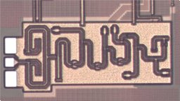
This paper presents the design and characterization of a two-element 81-86 GHz phased-array beamformer in SiGe BiCMOS for backhaul communication applications. Each transmitter path integrates power-amplifier (PA), power detector, variable attenuators, driver amplifier and a 6-bit phase shifter. The TX front-end achieves 24 dB small signal gain, gain bandwidth of 12 GHz, 17 dBm saturated output power and 14 dBm output-referred 1 dB compression point. The phase shifter achieve full 360° phase span with 6-bit phase resolution, 1.9° rms phase error and 0.11 dB rms gain error at 83 GHz. The IC occupies area of 5.1 mm2 (including pads) and consumes 312 mW per element at P1dB.
Submarine canyons are prominent features in continental slopes. They play an important role in sediment transport to the deep sea, as they form conduits for turbidity currents and cause landslides due their steep slopes. Such mass transport events could create geo-hazards, which compromise infrastructures along the continental slope. Our research focuses on the Nahariya Canyon, which is part of a series of submarine canyons located along the continental slopes of the eastern Mediterranean, offshore northern Israel. This canyon is incised into the slope and does not reach the shelf. Here, we report the results from a study of two piston cores sampled in the canyon at water depths of 650m (NAC650, ~2.5m long) and 915m (NAC915, ~6m long). Chronologies were established based radiocarbon dating using slope foraminiferal shells, in addition to 210Pb and OSL dating of bulk sediment. The sediments were characterized by major and trace element concentrations, mineralogy, grain size, and dead foraminiferal assemblages. We further identified the living (Rose-Bengal stained) foraminiferal species at three depths habitats (200m 650m and 915m water depth). Our results show that both piston cores are comprised of a capping ~40 cm thick interval of fine laminated mud, deposited over the last ~150-200 years, apparently reflecting hemipelagic sedimentation. This capping interval unconformably overlays a consolidated sequence in both cores, which indicates a major sediment removal. The consolidated sequence in NAC650 is mostly homogenous and dates to the previous glacial (>140 ka), and in NAC915 the upper 70 cm of the consolidated sequence consists mud clasts dated to 27-46 ka that overlay an ‘S shape’ shear zone, which is a result of a down canyon mass wasting (debrite). Below that debrite, the sediment is mostly homogenous and dates to the last glacial (>25 ka). Broken shells of shallow benthic foraminiferal species such as Ammonia spp., Asterigerinata mamilla, Miliolids, Rosalina spp. and Sorites orbiculus are found abundantly throughout both piston-cores, varying between in-core intervals, indicating that allochthonous sediments are prevalent at those cores. Same shallow species are found also in the surface (living) assemblages, mixed with slope deep foraminiferal species. Moreover, the deep living foraminiferal shells are well preserved, in contrast to the shallow living species. Taken together, these indicate that sediment transport processes along the canyon exist to this day. The cores suggest that the canyon is an erosive environment at least since the last glacial maximum, when the last significant mass wasting deposit is recorded. The Holocene is not represented in the records, probably due to the dominance of erosion processes, except for a thin layer of sediment deposited over the last two centuries that prevails along the entire canyon.
Our study comprises a high-resolution multi-proxy investigation of a ~6 m long piston core DOR280, sampled from the headscarp of a mapped landslide on the upper continental slope (280 m water depth) at the Dor Disturbance area, northern central Israel. The core retrieved the sediment sequence overlaying the sliding plane of the last major landsliding event. Benthic foraminiferal assemblages and taphonomy, alongside particle size distribution, were used to determine the provenance, transport distance, and reoccurrence time of mass transport events in this area. Radiocarbon ages were measured along the core revealed an age of ~600 Cal Yrs. B.P. for the core base, suggesting unexpectedly high average sedimentation rate of ~10 m/kyr, which is highest at the core top meter. Computed Tomography (CT) of DOR280 shows two alternating sedimentary facies: 5 – 208 cm thick Non-Laminated (NL) and 5 – 37 cm thick Laminated (L). The L-facies sequences also include 0 – 4 cm thick High-Density Laminas (HDL). The NL-facies intervals consist of unimodal fine-sediments dominated by clay minerals. Their foraminiferal assemblage is dominated by autochthonous species (e.g. Uvigerina spp.) and low percentage of broken shells. This indicates that the NL-facies represents mostly in-situ hemipelagic deposition. The L-facies intervals also record unimodal size-distribution of fine-sediments dominated by clay minerals, but their foraminiferal assemblages are dominated by allochthonous species (e.g. Ammonia spp.) and high percentage of broken shells, indicating a contribution of transported sediments, originated from mid-shelf habitats. The HDL-facies consist of bimodal sediments comprised of fine silty-clay (~5 µm) and coarse silty components (~40 µm), dominated by quartz and calcite; as well as poorly preserved and broken shells of allochthonous foraminifera species. Thus, the HDL represent significant contribution of mid-shelf-origin sediments and are interpreted as turbidite-like mass transport events. The temporal distribution of the 27 HDL events is nonrandom, revealing clusters at 59 ± 14 (n=9), 134 ± 12 (n=8), 453 ± 21 (n=4) and 641 ± 10 (n=4) years before present. These findings show prevailing cross-shelf and down slope sediments transport in the Dor Disturbance area. The HDL events can be triggered by large remote earthquakes (> 6.5), tsunami, winter storms or by sediment load that coincided with high-stand Nilotic episodes. However, mechanisms controlling the observed recent mass transport in the Dor Disturbance area still need to be studied. DOR280 is the first piston core studied in high resolution at the upper continental slope of of the Isreali offshore. The use of benthic foraminifera assemblages and their shells taphonomy reveals the transported sediments within the core and enables an assessment regarding their source. The findings reported here identified much higher sediments accumulation rate than previously known and thus have implications to the evaluation and mitigation of marine geo-hazard in the studied area.
Deep submarine groundwater discharge (DSGD) of fresh-brackish water was suggested to occur globally, yet its driving mechanism is not well constrained. Specifically, it is unclear whether the phenomenon may represent a steady-state condition of a hydrological system, in which the terrestrial recharge area is hydraulically connected with the submarine discharge area (by a confined aquifer, for example). Recently, our hydrogeological modeling suggested that such a system exists in northern Israel. The model predicted the location of a brackish water seepage within the Achziv Submarine Canyon, similar to 10 km offshore, where the Cretaceous Judea Group confined aquifer is carved by the canyon. The present work is a field study that attempts to identify these brackish seeps in the water column of the canyon at the aquifer exposure. The field observations include salinity and temperature profiling of the water column along the canyon during three cruises and Ra-224 measurements of water samples from the canyon. The results point to a significant near-bottom low-salinity and low-temperature anomaly right where the aquifer submarine outcrop is mapped that coincide with a high Ra-224 activity anomaly. Such near-bottom anomalies are absent in an adjacent submarine canyon, in which the confined aquifer is not exposed. The anomalies in the water column of the Achziv Submarine Canyon corroborate the results of the hydrogeological modeling that predicted brackish DSGD from the sea bottom at the aquifer outcrop. The possibility of DSGD in specific geo-hydrological settings is relevant for various biological, geochemical, hydrological, and geotechnical studies of the marginal ocean.
 Danny Elad合作论文数31
 Benny Sheinman合作论文数25
 Roi Carmon合作论文数25
 Roee Ben Yishay合作论文数Department of Electrical Engineering, Israel Institute of Technology18
 E. Aharonov合作论文数Weizmann Institute of Science18
 Run Levinger合作论文数Haifa Labs., IBM;c;Haifa Labs., IBM15
 Nadav Mazor合作论文数Haifa Labs., IBM;c;Haifa Labs., IBM14
 R. Ben-Yishay合作论文数12
 Naomi Porat合作论文数Geological Survey of Israel11
 Mor Kanari合作论文数Israel Oceanog & Limnol Res, Dept Marine Geol & Geophys, IL-31080 Haifa, Israel9
 Hyams-Kaphzan Orit合作论文数9
 Yariv Hamiel合作论文数Geological Survey of Israel9Amit Mushkin合作论文数8Onn Crouvi合作论文数Geological Survey of Israel8
 Shmuel Marco合作论文数Geophysics and Planetary Sciences;Tel Aviv University;Geophysics and Planetary Sciences, Tel Aviv University7
 Ze'ev Reches合作论文数Department of Geology, School of Geophysics, University of Oklahoma6Julia K. Morgan合作论文数Department of Earth, Environmental and Planetary Sciences, Wiess School of Natural Sciences, Rice University6Rivka Amit合作论文数Geological Survey of Israel6A. Bruetbart合作论文数5Ahuva Almogi-Labin合作论文数Geological Survey of Israel5
 Jakob Vovnoboy合作论文数5Ran Shemesh合作论文数4
 Omri Gadol合作论文数Charney School of Marine Sciences, University of Haifa4Anner Paldor合作论文数4Frank Szenher合作论文数4
 Beverly N. Goodmantchernov合作论文数4
 Ari Matmon合作论文数The Institute of Earth Sciences, Hebrew University of Jerusalem4
 Abramovich Sigal合作论文数Department of Earth and Environmental Sciences, הפקולטה למדעי הטבע, Ben-Gurion University of the Negev4
 Yizhaq Makovsky合作论文数Department of Geophysics;Stanford University;Department of Geophysics, Stanford University4Donald Papae合作论文数4
 Oliver Dabson合作论文数3
 Lorena Moscardelli合作论文数Bureau of Economic Geology, Jackson School of Geosciences, University of Texas at Austin3
 Matthew B. Weller合作论文数Lunar & Planetary Inst3a golberg合作论文数3Amos Salamon合作论文数3
 Ram Weinberger合作论文数Geological Mapping Division, Geological Survey of Israel3
 Pere Masqué合作论文数School of Science, Edith Cowan University;Oceans Institute, The University of Western Australia;School of Physics, The University of Western Australia3
 Sebastian Krastel合作论文数Institut für Geowissenschaften, Christian-Albrechts-Universität zu Kiel;Mathematisch-Naturwissenschaftliche Fakultät, Christian-Albrechts-Universität zu Kiel3Tsafrir Levi合作论文数3
 Yossef Hodara Hatzor合作论文数Department of Geological Environmental Sciences, Ben-Gurion University of the Negev3
 Zohar Gvirtzman合作论文数Institute of Earth Sciences;Hebrew University;Institute of Earth Sciences, Hebrew University3
 Aaron Micallef合作论文数National Oceanography Centre3Ron Shaar合作论文数Institute of Earth Sciences, The Hebrew University of Jerusalem3
 Brandon Dugan合作论文数Department of Earth Science, Rice University3
 Ricardo Leon合作论文数Instituto Geológico y Minero de España3
 Gony Yagoda-Biran合作论文数Department of Geological and Environmental Sciences, Ben-Gurion University of the Negev3
 Patrick J. McGovern合作论文数International Data Group3Beverly Goodman‐Tchernov合作论文数2




