Grasslands are worldwide spread ecosystems involved in the provision of multiple functional services, including biomass production and carbon storage. However, the increasingly adverse climate and non-optimised farm management are threatening these ecosystems. In this study, the original semi-mechanistic remotely senseddriven VISTOCK model, which simulates grass growth as limited by thermal and water stress, was modified and integrated with the RothC model to simulate the ecosystem fluxes. The new model (GRASSVISTOCK) showed satisfactory performance in simulating above-ground biomass (AGB) in dry matter (d.m.) and fractional transpirable soil water (FTSW) along Alps (AGB, RMSE = 85.39 g d.m. m- 2; FTSW, RMSE = 0.21) and Mediterranean (AGB, RMSE = 136.84 g d.m. m- 2; FTSW, RMSE = 0.13) grasslands. Also, GRASSVISTOCK was able to simulate the net ecosystem exchange (NEE - RMSE = 0.03 Mg C ha- 1), the gross primary production (RMSE = 0.04 Mg C ha- 1), the ecosystem respiration (RMSE = 0.04 Mg C ha- 1) and the evapotranspiration (RMSE = 1.44 mm), where these observations were available (Alps). The model was applied under present and two climate datasets characterised by temperature increase and precipitation decrease (+2 degrees C temperature, -10 % precipitation) and reference or enriched CO2 concentration (394 vs. 540.5 ppm) scenarios. The results showed that, while changes in temperature and precipitation alone had a negative impact by increasing NEE (+0.69 Mg C ha- 1) and decreasing total biomass (-0.20 Mg d.m. ha- 1) in the reference CO2 scenario, the enriched atmospheric CO2 concentration partially smoothed the NEE trend (+0.27 Mg C ha- 1) and increased total biomass (+0.60 Mg d.m. ha- 1) compared to the present period. It is concluded that the GRASSVISTOCK model represents a first step towards an integrated tool for estimating the performance of the agro-pastoral systems in terms of biomass production, water and carbon fluxes, in the face of ongoing climate change.
Budbreak plays an important role in the grapevine growing cycle and temperature is its main driver. Therefore, phenological models use two temperature-based approaches to simulate budbreak: a chilling-forcing scheme, which describes either endo- and eco-dormancy periods, or a forcing-approach, which exclusively simulates the eco-dormancy period. Both approaches are able to estimate budbreak under current temperature conditions, but they diverge under future climate forecasts. Additional divergences in phenological estimation are driven by climate as simulated by different global and regional circulation models and GHG concentration scenarios. Thus, this study explored the sources of uncertainty in budbreak estimation across Europe in a historical baseline (1976-2005) and near-future (2026-2055) climate. The experimental design comprised six phenological models calibrated for eight distinct grapevine varieties. These phenological models were applied to one historical and two future representative concentration pathways using different combinations of regional and global climate models according to data availability. In total, 25 experiments were performed for the historical period and 35 for the near-term future (18 and 17 for RCP2.6 and RCP4.5 scenarios respectively). The results showed different spatial domains of uncertainty across Europe. The total uncertainty in estimating budbreak was low in Central Europe and increased outside these regions in both the historical and future periods. Specifically, the uncertainty in the baseline period was mainly related to the phenological models (~94.7 %) with slight spatial differences across the study area. In the future period, Central Europe was characterised by high uncertainties due to the climate models (~40 %). Outside these regions, uncertainty increased due to the phenological models, the highest uncertainties being associated with the Mediterranean basin for the cold-adapted varieties, while the north/northeast regions showed the highest uncertainties for the warm-adapted varieties. High temperatures resulted in low daily chilling rates for BRIN, while only certain temperatures positively contributed for UNIFIED and UNICHILL. Additionally, low temperatures did not accumulate forcing units for any phenological model, while an increase in temperature led to a linear (GDD, Richardson-BRIN until a threshold) or parabolic (WANG, UNIFORC) increase in the daily forcing unit rate. These differences limit the use of the phenological models, which will need to be taken into account when applying these models in their application in different environments in the future.
The decline of semi‐natural open ecosystems after land abandonment is a conservation issue in many industrialized countries. Large herbivores, such as horses ( Equus ferus ), are excellent candidates for rewilding activities, as they can contribute to reducing loss of open landscapes. However, their presence could affect the spatio‐temporal distribution of sympatric species, especially if the reintroduction is unplanned and uncontrolled. La Calvana, central Italy, is a protected area with a mammalian community that has never been systematically monitored, and its grasslands, which are a high conservation priority, are disappearing. The area hosts a population of feral horses that originated about 40 years ago from a few released domestic individuals, and their unplanned presence could represent a unique rewilding opportunity for the restoration of the abandoned landscape. Yet nothing is known about their distribution or relationships with sympatric mammals. By deploying 40 camera traps in May‐July 2022, we systematically monitored the area to investigate spatio‐temporal patterns of feral horses and their relationships with environmental, biotic, and anthropogenic factors. We detected 12 wild mammal species and estimated that horses were present in 40% of the study area. None of the environmental variables tested affected the occupancy of horses, although modeling of site‐use intensity revealed that this species used upper‐ridge grasslands more frequently. This suggests the area is suitable to support the population and that their presence at higher elevations can be an asset to preserving grasslands by limiting forest and shrub encroachment. Horses occupancy was not related to the relative abundance of wild ungulates, suggesting minimal competition for resources at present. However, the lower temporal overlap at sites with greater vegetation cover during the hottest hours indicated dominance of horses. Feral horses seem unaffected by human proximity, although they are occasionally subject to poaching. Lastly, the 7‐year‐long population census revealed a 12% annual growth rate that may lead to exceeding the carrying capacity of the ecosystem in the future. We recommend continued monitoring of this population and implementation of conservation and management programs.
This study presents the application of advanced radio frequency (RF) sensors for non-invasive, plant structurespecific water stress monitoring in olive trees (Olea europaea L.), focusing on the cultivars Frantoio and Leccino, known for their differing water-use strategies. The sensing system comprises circular and double-layer rectangular spiral RF sensors, optimised to maximise the quality factor (Q-factor) for enhanced sensitivity. The double-layer design, where one layer is "left-handed" and the other "right-handed," allows for an increased magnetic field and detection reliability, especially on small branches where signal stability can be challenging. Throughout an 88-day experimental period, olive trees were subjected to full irrigation (FI) and deficit irrigation (DI) treatments. RF sensors were placed on the olive plants trunks and branches to capture plant structurespecific stress responses, with measurements recorded weekly. In the Frantoio cultivar, resonance frequency shifts were pronounced under DI, especially in the trunk and large branches, where notable physiological changes were observed. Correlations were established between resonance frequency data and morphophysiological indicators such as trunk diameter increment (SDI) and fresh water content (FWC), validating the sensor's sensitivity to dielectric property variations due to water stress. Anatomical analyses further revealed tissue adaptations in Frantoio under DI, including increased bark and cortex thickness and intensified sclerenchyma fibre formation, indicative of structural changes to support water transport. In contrast, the Leccino cultivar showed minimal frequency variations and lacked significant anatomical alterations, reflecting its conservative water-use strategy and limited sensitivity to stress. This research confirms RF sensors' potential as precise tools for early water stress detection in olive trees, with an emphasis on sensor placement on main plant structures and sensitivity optimization to enhance accuracy. These findings support the use of RF sensing systems in precision agriculture for sustainable irrigation management, especially in water-limited environments and conditions.
Historic gardens are green spaces characterised by tree stands with several veteran specimens of high artistic and cultural value. Such valuable plant components have to cope with biotic and abiotic stress factors as well as ongoing senescence processes. Maintaining tree health is therefore crucial to preserve their ecosystem services, but also to protect the monument and visitor health. In this context, finding smart, fast and cost-effective management solutions to monitor health and detect critical conditions for both stands and individual veteran trees can promote garden conservation. For this reason, we developed a novel framework based on Sentinel2 imagery, LiDAR sources and automatic cameras to identify risk spots regarding trees in historic gardens. The pilot study area consists of two closed Italian gardens from the 16th century, which were analysed as a unique Historic Garden System (HGS). The tree health status at stand level was assessed using a criterion based on the Normalized Difference Vegetation Index weighed on tree volume (NDVIt) and validated by a visual crown defoliation assessment. At the tree level, the health status of four veteran trees defined by the NDVIt was also evaluated using green chromatic coordinates (GCC) obtained from digital images acquired by cameras at daily intervals during one growing season. The 33% of the tree population was classified as being in poor health, i.e. "at risk". Veteran trees classified as "at risk" showed an anticipation of phenological phases and a lower GCC compared to reference trees. Despite variability determined by Sentinel medium resolution, the proposed framework showed good accuracy (0.74) for monitoring historical gardens. The semi-automatic risk point mapping system tested here proved to be effective in facilitating the management of historic gardens, which in turn could be applied in the wider context of urban greening.
The purpose of this paper is to present the results of a pilot project implementation of PLM solution based on blockchain technology in the ancient grains Italian Industry. After a literature review on previous experience of blockchain technology in the food Industry, a case study analysis has been done to identify the actors along the supply chain of durum wheat for pasta production, as well as to study the main regulations for wheat production. Moreover, possible weaknesses and strengths in the application of the blockchain for the ancient wheat supply chain have been highlighted. Finally, the main evidences of the pilot project are reported and a set of information systems able to manage the product lifecycle have been identified. The paper provides valuable insights to companies that are trying to implement such solution in the food Industry.
Virtual Fencing (VF) can be a helpful technology in managing herds in pasture-based systems. In VF systems, animals wear a VF collar using global positioning, and physical boundaries are replaced by virtual ones. The Nofence (Nofence AS, Batnfjords & oslash;ra, Norway) collars used in this study emit an acoustic warning when an animal approaches the virtual boundaries, followed by an aversive electrical pulse if the animal does not return to the defined area. The stimuli sequence is repeated up to three times if the animal continues to walk forward. Although it has been demonstrated that animals successfully learn to adapt to the system, it is unknown if this adaptation changes with animal age and thus has consequences for VF training and animal welfare. This study compared the ability of younger and older dairy cows to adapt to a VF system and whether age affected activity behavior, milk yield, and animal long-term stress under VF management. The study was conducted on four comparable strip-grazing paddocks. Twenty lactating Holstein-Friesian cows, divided into four groups of five animals each, were equipped with VF collars and pedometers. Groups differed in age: two groups of older cows (>4 lactations) and two groups of younger ones (first lactation). After a 7-d training, paddock sizes were increased by successively moving the virtual fence during four consecutive grazing periods. Throughout the study, the pedometers recorded daily step count, time spent standing, and time spent lying. For the determination of long-term stress, hair samples were collected on the first and last day of the trial and the hair cortisol content was assessed. Data were analyzed by generalized mixed-effect models. Overall, age had no significant impact on animal responses to VF, but there were interaction effects of time: the number of acoustic warnings in the last period was higher in younger cows (P < 0.001), and the duration of acoustic warnings at training was shorter for older cows (P < 0.01). Moreover, younger cows walked more per day during the training (P < 0.01). Finally, no effects on milk yield or hair cortisol content were detected. In conclusion, all cows, regardless of age, adapted rapidly to the VF system without compromising their welfare according to the indicators measured.
Future climate change is expected to significantly alter the growth of vegetation in grassland systems, in terms of length of the growing season, forage production, and climate-altering gas emissions. The main objective of this work was, therefore, to simulate the future impacts of foreseen climate change in the context of two pastoral systems in the central Italian Apennines and test different adaptation strategies to cope with these changes. The PaSim simulation model was, therefore, used for this purpose. After calibration by comparison with observed data of aboveground biomass (AGB) and leaf area index (LAI), simulations were able to produce various future outputs, such as length of growing season, AGB, and greenhouse gas (GHG) emissions, for two time windows (i.e., 2011–2040 and 2041–2070) using 14 global climate models (GCMs) for the generation of future climate data, according to RCP (Representative Concentration Pathways) 4.5 and 8.5 scenarios under business-as-usual management (BaU). As a result of increasing temperatures, the fertilizing effect of CO2, and a similar trend in water content between present and future, simulations showed a lengthening of the season (i.e., mean increase: +8.5 and 14 days under RCP4.5 and RCP8.5, respectively, for the period 2011–2040, +19 and 31.5 days under RCP4.5 and RCP8.5, respectively, for the period 2041–2070) and a rise in forage production (i.e., mean biomass peak increase of the two test sites under BaU: +53.7% and 62.75% for RCP4.5. and RCP8.5, respectively, in the 2011–2040 period, +115.3% and 176.9% in RCP4.5 and RCP8.5 in 2041–2070, respectively,). Subsequently, three different alternative management strategies were tested: a 20% rise in animal stocking rate (+20 GI), a 15% increase in grazing length (+15 GL), and a combination of these two management factors (+20 GI × 15 GL). Simulation results on alternative management strategies suggest that the favorable conditions for forage production could support the increase in animal stocking rate and grazing length of alternative management strategies (i.e., +20 GI, +15 GL, +20 GI × 15 GL). Under future projections, net ecosystem exchange (NEE) and nitrogen oxide (N2O) emissions decreased, whereas methane (CH4) rose. The simulated GHG future changes varied in magnitude according to the different adaptation strategies tested. The development and assessment of adaptation strategies for extensive pastures of the Central Apennines provide a basis for appropriate agricultural policy and optimal land management in response to the ongoing climate change.
The use of very long spatial datasets from satellites has opened up numerous opportunities, including the monitoring of vegetation phenology over the course of time. Considering the importance of grassland systems and the influence of climate change on their phenology, the specific objectives of this study are: (a) to identify a methodology for a reliable estimation of grassland phenological dates from a satellite vegetation index (i.e., kernel normalized difference vegetation index, kNDVI) and (b) to quantify the changes that have occurred over the period 2001–2021 in a representative dataset of European grasslands and assess the extent of climate change impacts. In order to identify the best methodological approach for estimating the start (SOS), peak (POS) and end (EOS) of the growing season from the satellite, we compared dates extracted from the MODIS-kNDVI annual trajectories with different combinations of fitting models (FMs) and extraction methods (EM), with those extracted from the gross primary productivity (GPP) measured from eddy covariance flux towers in specific grasslands. SOS and POS were effectively identified with various FM×EM approaches, whereas satellite-EOS did not obtain sufficiently reliable estimates and was excluded from the trend analysis. The methodological indications (i.e., FM×EM selection) were then used to calculate the SOS and POS for 31 grassland sites in Europe from MODIS-kNDVI during the period 2001–2021. SOS tended towards an anticipation at the majority of sites (83.9%), with an average advance at significant sites of 0.76 days year−1. For POS, the trend was also towards advancement, although the results are less homogeneous (67.7% of sites with advancement), and with a less marked advance at significant sites (0.56 days year−1). From the analyses carried out, the SOS and POS of several sites were influenced by the winter and spring temperatures, which recorded rises during the period 2001–2021. Contrasting results were recorded for the SOS-POS duration, which did not show a clear trend towards lengthening or shortening. Considering latitude and altitude, the results highlighted that the greatest changes in terms of SOS and POS anticipation were recorded for sites at higher latitudes and lower altitudes.
Climate change is currently threatening agro-pastoral systems around the world. Increased temperature and prolonged drought periods are reducing the capacity of these environments to provide several ecosystem services and their potential to mitigate climate change. In this context, grasslands and pastures monitoring gains a relevant importance for improving farm management and productivity, farmer incomes and to reduce input wastage and greenhouse gases emissions. In these perspectives, many crop models have been adopted with the purpose of allowing an accurate grassland monitoring, to promptly detect the impact of eventual abiotic stresses (e.g. thermal and water stresses) and to identify adequate adaptation strategies to cope with climate change. In this study, the grassland growth model GRASSVISTOCK was implemented for simulating the soil water dynamics and fluxes as well as their impacts on leaf area index (LAI) and above-ground biomass (AGB) in three Alpine (A, B and C) and three Mediterranean (D, E and F) grasslands. The results showed good model performances at simulating soil fractional transpirable soil water (FTSW) in the Alpine sites (site B: r=0.81; RRMSE=44.42%; site C: r=0.78; RRMSE=33.43%) while no comparisons between observed and simulated FTSW were performed for the other grasslands due to less data availability. The model also showed satisfactory performances at estimating LAI and AGB in both Alpine (LAI: r=0.66; RRMSE=33.03%; AGB: r=0.60; RRMSE=35.54%) and Mediterranean (LAI: r =0.85; RRMSE=43.58%; AGB: r=0.77; RRMSE=28.02%) sites. On these bases, this study proposes a prognostic tool for estimating water fluxes with the purpose of supporting agronomic decisions and to improve the sustainability of agro pastoral systems.
To quantify the impacts of climate change on agricultural systems and to support policy processes and farm level decisions, the agricultural meteorology community is extensively applying climate-crop modelling approaches. The herein study evaluates the impact of two climate change scenarios (Representative Concentration Pathways-RCPs 4.5 and 8.5) on main crops (millet, sorghum and cowpea) grown in two agroclimatological regions (Soudano-Sahelian and Sahel) in the Republic of Niger. Climate projections using HadGEM2-ES model show increasing precipitation trends of up to + 30 % under RCP 8.5 in Birni N ' Konni (Soudano-Sahelian) and a decrease of 1 % under RCP 4.5 in Mare de Tabalak (Sahel) when comparing the 2021-30 and 2071-80 periods. The number of dry days and heavy rainfall events during the wet-season are also expected to gain in frequency over the century. As a result, the productivity of major crops is threatened, with potential dire consequences for national food security and the income of millions. The emerging findings of the crop-modelling work using AquaCrop show a decrease/increase yield trends for millet, sorghum and cowpea of about 0 to -50 %, + 5 to -20 %, + 11 to + 18 %, respectively, by the end of the century (2060-80), depending on the agroclimatic zone, sowing date and RCP. Overall, the emerging findings of this work can be used to inform agricultural trans-formation and adaptation to climate change by promoting a higher resilience against both excess of water (due to high rainfall events) and lack of water resources (due to extended dry periods).
This article presents the structure and results of a simplified model (VISTOCK) for simulating grass growth and water dynamics of grassland systems. The model, based on a process-based approach coupled with proximal (SKR 1800 2-Channel Light Sensor) and remote (Sentinel-2) NDVI-derived data for estimating LAI, simulates aboveground biomass (AGB), net primary production (NPP), evapotranspiration (ET), and the fraction of transpirable water in soil (FTSW). VISTOCK simulated a grassland system with few meteorological data (i.e., minimum and maximum daily temperatures, precipitation, global solar radiation), considering limitations to vegetation growth due to thermal and water stresses. It was calibrated for a natural alpine grassland in Italy (site T) during the most contrasting meteorological seasons of the dataset (2012, 2017, and 2018). It was then evaluated for the remaining years at site T (2013, 2014, 2015, and 2016) and for other two sites in Italy (sites B1, B2 and M) with different soil and climate conditions and diverse management strategies (2020 and 2021). VISTOCK accurately predicted AGB during the growing season (RMSE = 445, 240, 219, 365 kg DM ha-1 for T, M, B1, and B2, respectively) as well as for NPP, ET, and FSTW at site T. Simulation results suggest the ability of the model to simulate grassland in diverse environments with few inputs and parameters to be calibrated. The model's simplified structure, combined with easy-to obtain input data and easy applicability, encourages its wider use for out- and/or upscaling and decision making.
The implementation of novel precision viticulture approaches is a pivotal research topic for accurately assessing spatial and temporal variability of the water resource in rainfed fields. In this view, the SOSVITE project aims to model the hydrological status of the vineyard by integrating data derived from different proximal and remote sensing technologies. The methodology applied in this study to disentangle the vines’ signal from that of spontaneous grass from satellite data has the potential to accurately estimate the dynamics of water-related plant parameters which, together with in-situ pedo-climatic measurements, can serve as input of existing growth models. Therefore, this study represents the first step towards the development of a decision support system for guiding winegrowers in the adoption of proper management techniques to face with the expected scarcity of water due to climate change in the Mediterranean basin.
•A sustainable use of pasture-based systems requires efficient grazing management.•Virtual Fencing uses acoustic and electric cues to replace physical fences.•Cow's learning ability was tested by setting three different virtual grazing areas.•Results show a significant decrease of sounds and electrical pulses among trials.•Hair cortisol content was not affected by Virtual Fencing management.
Olive tree cultivation is currently a dominant agriculture activity in the Mediterranean basin, where the increasing impact of climate change coupled with the inefficient management of olive groves is negatively affecting olive oil production and quality in some marginal areas. In this context, satellite imagery may help to monitor crop growth under different environmental conditions, thus providing useful information for optimizing olive grove management and final production. However, the spatial resolution of freely-available satellite products is not yet adequate to estimate plant biophysical parameters in complex agroecosystems such as olive groves, where both olive trees and grass cover contribute to the vegetation indices (VIs) signal at pixel scale. The aim of this study is therefore to test a disentangling procedure to partition the VIs signal among the different components of the agroecosystem to use this information for the monitoring of olive growth processes during the season. Specifically, five VIs (GEMI, MCARI2, NDVI, OSAVI, MCARI2/OSAVI) as recorded by Sentinel-2 at a spatial resolution of 10 m over five olive groves in the Montalbano area (Tuscany, Central Italy), were tested as a proxy for olive tree intercepted radiation. The olive tree volume per pixel was initially used to linearly rescale the VIs signal into the relevant value for the grass cover and olive trees. The models, describing the relationship between rescaled VIs and observed fraction of Photosynthetically Active Radiation (fPAR), were fitted and then validated against independent datasets. While in the calibration phase, a greater robustness at predicting fPAR was obtained using NDVI (r = 0.96 and RRMSE = 9.86), the validation results demonstrating that GEMI and MCARI2/OSAVI provided the highest performances (GEMI: r = 0.89 and RRMSE = 21.71; MCARI2/OSAVI: r = 0.87 and RRMSE = 25.50), in contrast to MCARI2 that provided the lowest (r = 0.67 and RRMSE = 36.78). These results may be related to the VIs' intrinsic features (e.g., lower sensitivity to atmosphere and background effects), which make some of these indices, compared to others, less sensitive to saturation effects by improving fPAR estimation (e.g., GEMI vs. NDVI). On this basis, this study evidenced the need to improve the current methodologies to reduce inter-row effects and select appropriate VIs for fPAR estimation, especially in complex agroecosystems where inter-row grass growth may affect remote sensed-derived VIs signal at an inadequate pixel resolution.
Mountain grazing lands are key constituents of the natural, economical and cultural heritage, but at the same time sensitive to climate and land use change, hence requiring urgent adaptation and management strategies. These must be based on a better understanding of the distribution of mountain pastoral resources across space and time. In this study we model the distribution and the productivity of grassland surfaces in a topographically complex protected area (Gran Paradiso National Park, 710 km2) in north-western Italian Alps. The objective of our work was threefold: a) modelling the distribution of mountain grasslands across the entire park at a 20-meters spatial resolution, b) classify pastoral surfaces according to productivity classes, and c) according to thirteen pastoral categories. We used a random forest approach to combine a massive terrain vegetation survey as ground truth, with remote-sensing-derived, climatic and topographic layers as predictors. Grassland presence/absence was classified with high accuracy (up to 88%) and, compared to the standard Copernicus European Grassland Product, revealed the presence of extensive high altitude grassland areas potentially available for wild herbivores. Grassland productivity was modelled with remarkably high accuracy both according to three broad productivity classes (90% accuracy) and to a more detailed classification into thirteen pastoral categories (83% accuracy). Productivity estimates agree well with satellite-derived leaf area index maps and with area-averaged NDVI seasonal patterns. We conclude that combining tailored field campaigns and high-resolution remote sensing allows for robust prediction of grassland distribution and productivity even in complex terrains. This information can contribute to improve the management of pastoral resources and promote effective adaptation strategies.
Crop rotation, fertilization and residue management affect the water balance and crop production and can lead to different sensitivities to climate change. To assess the impacts of climate change on crop rotations (CRs), the crop model ensemble (APSIM,AQUACROP, CROPSYST, DAISY, DSSAT, HERMES, MONICA) was used. The yields and water balance of two CRs with the same set of crops (winter wheat, silage maize, spring barley and winter rape) in a continuous transient run from 1961 to 2080 were simulated. CR1 was without cover crops and without manure application. Straw after the harvest was exported from the fields. CR2 included cover crops, manure application and crop residue retention left on field. Simulations were performed using two soil types (Chernozem, Cambisol) within three sites in the Czech Republic, which represent temperature and precipitation gradients for crops in Central Europe. For the description of future climatic conditions, seven climate scenarios were used. Six of them had increasing CO & nbsp;concentrations according RCP 8.5, one had no CO2 increase in the future. The output of an ensemble expected higher productivity by 0.82 t/ha/year and 2.04 t/ha/year for yields and aboveground biomass in the future (2051-2080). However, if the direct effect of a CO2 increase is not considered, the average yields for lowlands will be lower. Compared to CR1, CR2 showed higher average yields of 1.26 t/ha/year for current climatic conditions and 1.41 t/ha/year for future climatic conditions. For the majority of climate change scenarios, the crop model ensemble agrees on the projected yield increase in C3 crops in the future for CR2 but not for CR1. Higher agreement for future yield increases was found for Chernozem, while for Cambisol, lower yields under dry climate scenarios are expected. For silage maize, changes in simulated yields depend on locality. If the same hybrid will be used in the future, then yield reductions should be expected within lower altitudes. The results indicate the potential for higher biomass production from cover crops, but CR2 is associated with almost 120 mm higher evapotranspiration compared to that of CR1 over a 5-year cycle for lowland stations in the future, which in the case of the rainfed agriculture could affect the long-term soil water balance. This could affect groundwater replenishment, especially for locations with fine textured soils, although the findings of this study highlight the potential for the soil water-holding capacity to buffer against the adverse weather conditions.
 Marco Moriondo合作论文数Ospedale Pediatrico Anna Meyer41
 Marco Bindi合作论文数DISAT-UNIFI40
 Giovanni Argenti合作论文数Department of Agronomy and Land Management;University of Florence;Department of Agronomy and Land Management, University of Florence27
 Roberto Ferrise合作论文数26
 Sergi Costafreda-Aumedes合作论文数Department of Agriculture, Food, Environment and Forestry (DAGRI),, University of Florence19
 Lorenzo Brilli合作论文数Department of Internal Medicine;Section of Endocrinology and Metabolism;University of Siena;Department of Internal Medicine, University of Siena19
 Nicolina Stagliano合作论文数16
 Giacomo Trombi合作论文数Earth System Science – Climate Change Group, Wageningen University and Research Centre14
 Luisa Leolini合作论文数Dept Agr Food Environm & Forestry DAGRI, Univ Florence13Gloria Padovan合作论文数University of Florence10
 Kurt Christian Kersebaum合作论文数Leibniz-Zentrum für Agrarlandschaftsforschung e.V./Department für Nutzpflanzenwissenschaften, Faculty of Agricultural Sciences, Georg-August-Universität Göttingen8
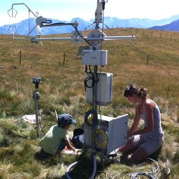 Marta Galvagno合作论文数Sez. Agenti Fisici, Agenzia Regionale per la Protezione dell’Ambiente della Valle d’Aosta8Edoardo Bellini合作论文数7
 Paolo Merante合作论文数7Christos Giannakopoulos合作论文数Institute for Environmental Research and Sustainable Development;National Observatory of Athens7
 Jørgen E. Olesen合作论文数Department of Agroecology, Aarhus University7Gianluca Filippa合作论文数Di.Va.P.R.A. (Dipartimento di Valorizzazione e Protezione delle Risorse Agroforestali) Chimica Agraria e Pedologia, Università degli Studi di Torino7
 Gianni Bellocchi合作论文数6João Santos Pereira合作论文数6
 Berta Sánchez合作论文数Res Ctr Management Agr & Environm Risks CEIGRAM, Univ Politecn Madrid6
 Fraga Helder合作论文数Centre for the Research and Technology of Agro-Environmental and Biological Sciences, Universidade de Trás-os-Montes e Alto Douro6Debbie Hemming合作论文数5
 Ana Iglesias合作论文数Department of Agricultural Economics and Social Sciences, Universidad Politecnica de Madrid;Department of Agricultural Economics and Social Sciences, Universidad Politecnica de Madrid5
 Mutasem El Fadel合作论文数Department of Civil Infrastructure and Environmental Engineering, Khalifa University5Christoph Menz合作论文数5
 Daniel Molitor合作论文数5
 Ali Harzallah合作论文数5
 C. M. Goodess合作论文数University of East Anglia Climatic Research Unit5
 Maureen D. Agnew合作论文数5
 Jose M. Grunzweig合作论文数Robert H. Smith Institute of Plant Sciences and Genetics in Agriculture, Hebrew University of Jerusalem5
 P. Lionello合作论文数Istituto Studio Dinamica Grandi Masse del CNR San Polo5Annalisa Tanzarella合作论文数5
 Edoardo Cremonese合作论文数Sez. Agenti Fisici, Agenzia Regionale per la Protezione dell’Ambiente della Valle d’Aosta5
 Theib Oweis合作论文数International Center for Agricultural Research in the Dry Areas5
 Hesham I. El-Askary合作论文数Faculty of Pharmacy, Cairo University5
 Agustin Sanchez-Arcilla合作论文数5Skander Ben Salem合作论文数4
 Niccolo Bartoloni合作论文数4
 Amit Kumar Srivastava合作论文数4
 Tommaso Stella合作论文数Leibniz Ctr Agr Landscape Res, Muncheberg, Germany4Mohamed El Raey合作论文数4
 Vakhtang Shelia合作论文数University of Florida4
 Marco Reale合作论文数National Institute of Oceanography and Experimental Geophysics4
 M. Launay合作论文数4
 Gerrit Hoogenboom合作论文数Department of Agricultural and Biological Engineering, University of Florida;Global Food Systems Institute, University of Florida;Institute for Sustainable Food Systems, University of Florida4Thomas Kartschall合作论文数4
 Mohamed Senouci合作论文数Membre du Groupe Intergouvernemental sur l’Evolution du Climat (IPCC),, ARCE4
 Basil Psiloglou合作论文数Institute of Meteorology and Physics of the Atmospheric Environment, National Observatory of Athens4Taru Palosuo合作论文数EFI ), European Forest Institute4




