The vertical component of surface afterslip of the 2008 Mw7.9 Wenchuan Earthquake, China, has been observed since 2011 using repeated levelings at the Yingxiu site, which spans the southwestern segment of the 2008 rupture. We present the geological, co-seismic rupture, and aftershock features around the Yingxiu site and employ the rate- and state-dependent friction theory to analyze the friction mechanism and depth of the afterslip. The logarithmically increasing afterslip series with a cumulative amount of -30 mm obeys a velocitystrengthening friction law, from which the afterslip depth is estimated to be 2.6-6 km. This depth is further constrained to -5 km that probably represents the thickness of a shallow velocity-strengthening layer of the fault, from information of sedimentary strata and aftershock distribution. The coseismic reverse vertical slip was <3 m around the Yingxiu site during the 2008 mainshock, whereas that on the adjacent rupture section to the northeast was >= 8 m above -15 km depth, including the largest slip of 12.5 m at -13 km depth (Zhang et al., 2012). These features suggest that an apparent deficit of coseismic slip existed on the rupture section at the Yingxiu site, compared with coseismic slip on the adjacent section. Furthermore, the surface-observed afterslip is uncorrelated with the aftershock slip on the fault in the underlying velocity-weakening layer. Therefore, the surface afterslip at the Yingxiu site is due to post-2008 relaxation that compensates for the coseismic slip deficit in the shallow layer of the fault and is probably governed by velocity-strengthening friction.
Rock deformations induced by active faults is an important topic in earthquake studies. Such deformations are usually measured with crossfault measurements (CFM), which are time-consuming and labor-intensive. In this study, rock deformations induced by the famous Xianshuihe fault in Xialatuo of China were estimated by groundwater-level monitoring (GLM) and CFM for the period of January 1, 2016 to December 31, 2018. The pattern of the variations in areal strain estimated with GLM matches that from CFM well. The estimated strain by the GLM and CFM both changed from positive to negative with time, indicating that the fault plane switched from tensile to compressive. This indicates that the rate of rock deformation had slowed down during this period, which is consistent with the long-term creep rates obtained by CFM at the site, implying that the fault may have gradually entered the next relock state. The estimated strain changes using the GLM method lag slightly behind those of CFM, which is probably due to the diffusive effects of pore pressure propagation that is caused by the rock deformation under the crustal stress. This study demonstrates that GLM is a more convenient and efficient addition to traditional geophysical techniques and raises the possibility for the characterization of continuous rock deformations. The method may be used to obtain the changing regional strain field with a network of monitoring wells.
本文综合运用地形、地质构造等基础信息,建立西昌地区的数值模型,定量分析由荷载引起的点位沉降变化等干扰对跨断层形变测量的影响.采用FLAC3D软件对包含西昌跨断层场地及附近尾矿库的数值模型进行计算,结果表明,尾矿库矿渣堆积不是引起西昌场地水准观测资料出现异常的原因.
The Anninghe-Zemuhe and Daliangshan fault zones are the western and eastern boundaries of the Daliangshan sub-block, respectively, both of which lie in a tectonic setting with potential major earthquakes. The purpose of this work is to estimate the seismogenic depths and seismic risks of these two fault zones relying on limited geodetic and seismic data. Firstly, we use a simple 2D elastic dislocation model to infer the slip rates and the locking depths along these fault zones. We calculate the 90%, 95% and 99% seismic cutoff depths and compare with those from GPS data. The results show that the locking depth of the north segment of the Anninghe fault is 6.2 km, less than half of 16 km for its 90% seismic cutoff depths. It implies that after the 1952 M(s)6(3/4)y, earthquake, this segment gradually tended to become locked. While within a depth range of 6-16 km, energy was released by seismic and aseismic slip, where exists deep creep. The north segment of the Daliangshan fault is completely locked within a depth range of 0 similar to 10 km, while the locking within 10 similar to 25 km is relatively weaker. The south segment of the Anninghe fault, the Zemuhe fault, middle and south of the Daliangshan fault are completely locked, of which the locking depths are close to the 90% cutoff depths of small events with a standard deviation of 0. 94 km. In addition, inversion of profiles A, B and C reveals that the movement of the Daliangshan sub-block from north to south exhibits clockwise rotation, consistent with the movement feature of the Sichuan-Yunnan block. The slip rates of the north, middle, and south segments of the Daliangshan sub-block are 9. 8 mm . a 1, 8. 9 mm . a 1 and 8. 4 mm . a 1, respectively, decreasing from north to south. The accumulated seismic moments of the Butuo fault and Jiaojihe fault, which lie in the south section of the Daliangshan fault, are capable to generate maximum magnitudes of M-W 7. 5 earthquakes, respectively. The elapsed times of the last events of these two faults are close to their earthquake recurrence intervals, and their earthquake occurrence probabilities are estimated to be 7. 1% and 5. 9%, respectively, which should receive much attention.
In this study, 1338 relocated earthquakes (M-s >= 1.6) from 1981 to 2018 and 53 GPS velocities from 2004 to 2017 were processed to obtain the geometry and kinematic characteristics of the Daofu-Kangding segment of the Xianshuihe fault system in southwestern China. By analyzing the seismicity depth distribution of the Selaha-Kangding fault, we inferred its three branches, the Yalahe fault, Selaha fault, and Zheduotang fault converged into one fault at a depth of approximately 15 km and that a flower-shaped structure was observed above this depth. Furthermore, based on a 2D elastic dislocation model, the creep rates, creep depths, slip rates, and locking depths of the Daofu-Kangding segment were analyzed. In case of the Daofu-Qianning fault, the obtained left-lateral slip rate was 4.5 +/- 1.1 mm/a and the locking depth was 5.3 +/- 1.9 km. Because the fault creep rate from a depth of 2.6 km to the surface was 1.3 +/- 1.0 mm/a, the Daofu-Qianning fault cannot generate earthquakes having magnitudes of greater than 7 in the near future. However, the slip rates were 7.5 +/- 1.6, 2.3 +/- 1.5, and 1.9 +/- 1.5 mm/a by assuming a locking depth of 15 km for the Selaha fault, Yalahe fault, and Zheduotang fault, respectively. Furthermore, because the creep depth of the Selaha fault was 3.4 +/- 1.6 km and the creep rate was 7.5 +/- 2.8 mm/a, the accumulated seismic moment since 1725 corresponded to a M(w)7.1 earthquake.
Water samples from rainfall, river, springs, and wells in the Xianshui River fault region near Xialatuo, China were collected during two sampling campaigns to investigate the complex groundwater circulation in the region. The major ions, stable isotopes, and four natural radium isotopes of the water samples were analyzed, and the results were utilized to identify different groundwater circulation depths. Most water samples excluding the one at a hot spring and the one at a borehole possess similar hydrochemical compositions and lower total dissolved solids (TDS), implying that their circulation depth is relatively shallow or that residence time is short. The sample at the hot spring has high TDS and high temperature as well as the high F concentration, inferring that it may circulate at a deeper depth. The sample at the borehole contains mixed hydrochemical characteristics of other samples. Three groundwater flow systems may exist in the study area: the shallow groundwater system recharged by precipitations and local groundwater flow, the deep groundwater system recharged by the regional groundwater flow, and the intermediate one between the above two systems. The finding of the three flow systems is supported by the δ2H and δ18O as well as the apparent radium ages of the samples. The δ2H and δ18O values at the intercept of the line formed by the shallow groundwater samples and the local meteoric water line (LMWL) are similar to those of modern precipitations. The δ2H and δ18O values at the intercept of the line formed by the deep groundwater samples and the LMWL show that it is probably recharged by relatively older precipitations. The 2H and 18O values of the borehole samples are between the above two intercept points. The deep-circulated groundwater with high temperature has longer apparent radium age than other water samples. The apparent radium ages of the shallow groundwater are similar but less than that of the deep groundwater. Groundwater at the borehole may circulate at a depth between the above two. The results of this study improve our understanding of the complex groundwater circulation and enable us to better protect and manage the groundwater resources in the region.
The Xianshuihe fault zone is divided into five segments along its strike. Fault activity parameters are estimated by using crossing fault measuring data of short baselines and short leveling at sites along the fault zone. Regional dynamic gravity and GPS velocity fields are calculated by using gravity and GPS observational data of a large area covering the whole fault zone. We use the ant colony algorithm and particle swarm optimization (PSO) based on resulting data above to invert the fault activity parameters of the five fault segments, and the strike-slip component of each segment is taken as the current fault slip rate. Then we analyze the differences between the three types of the current slip rate as well as geological average slip rates of the five segments, taking the strike slip rate inverted from gravity data as the slip rate of the whole fault zone. Comparing the whole near-field fault rate with the result of short baselines and short leveling, we determine the features of fault segments measured by short baselines and short leveling, and provide the current overall strike-slip rate of the five segments and several branch faults. The resulting slip rates are as follows: (1) 9. 13 mm . a(1) on the Luhuo segment; 2. 46 mm . a (1) on the west branch fault and 5. 84 mm . a (1) on the east branch fault in the Xialatuo area. (1) 8. 57 mm . a (1) on the Daofu segment; on its southeast section, the west branch in the Goupu is 1. 78 mm . a,and the east branch is 6. 79 mm . a (3) 7. 67 mm . a (1) on the Qianning segment. (4) 6. 14 mm . a (1) on the Kangding segment. And (5) 4. 41 mm . a (1) on the Moxi segment. Moreover, we also discuss qualitatively the 3D elastic-plastic deformation model of active blocks on both sides of the fault zone covered by gravity and GPS data and permanent displacements caused by paleoand historical earthquakes.
This study examines the ~200-km-long northwestern Xianshuihe fault zone (NWXFZ), southwestern China, using more than three decades of geodetic observations from fault-crossing short-baseline and short-leveling surveys at seven sites. These data enable estimates of creep rates and depths, and examination of the long-term slip behavior. The surface motion of the NWXFZ is dominated by sinistral creep, although sinistral, transverse, and vertical slip components show spatio-temporal variations. Combining these slip variations with data of earthquake rupture, coseismic slip, seismicity, fault geometry, and far-fault movement velocity, and using the velocity-and-state friction theory, our analysis indicates that the surface slip behavior of the NWXFZ is segmented along strike. The 1973 rupture section of this fault zone exhibits spatio-temporally variable slip behavior, showing time-decaying post-1973 afterslip on the northwestern and southeastern parts of the rupture at depths above 5.8−7.0km with average sinistral-creep rates of 1.3 and 3.5mm/yr, respectively, but being relocked in the central part of the rupture. The 1923/1981 rupture section is generally in locking state, with postseismic and interseismic sinistral-creep at 1.1mm/yr on its central part at depths above 2.0–2.8km. The 1893 rupture section has been tightly locked without creep since at least the early 1980s. The thickness of the shallow velocity-strengthening (or creep) layer and the restraining bend geometry of the NWXFZ are the key factors that control spatio-temporal variations in surface creep rates. Two surface-observed locked fault portions are located within two different restraining bends in the NWXFZ, both of which act as compressive asperities and hence have enabled the long-term locking of these portions. Creep along the NWXFZ has also been affected to varying degrees by M6.5−Mw9.2 earthquakes at distances of 50−3800 km from the fault zone. Most of these effects have been removed from our estimates of the long-term average creep rates.
文中系统整理并计算了1988年以来鲜水河断裂带地区流动重力复测资料,参照以往震例研究总结提出的重力场变化异常指标,分析了区域重力场时-空动态变化及其与测区内发生5级以上地震的关系,进一步研究了区域重力场变化的时-空分布特征及其机理,讨论了近期区域重力场动态变化的强震危险含义.结果表明:1)流动重力测量具备了检测地壳运动与5级以上地震事件的能力;2)1988年以来测区发生的13次5级以上地震中的8个地震与年际重力场变化有较为确定的对应关系,可依据年际重力场变化确定前兆异常,其中3个6级以上地震在异常图像发展3~4a后发生,4个发生在无资料区的地震事件不能确定前兆异常;3)测区重力场的1个明显特征是2004年以前区域重力场时空动态变化图像呈整体的南北贯通,且年度间为正、负值交替变化,其间所发生的5级以上地震不沿鲜水河断裂带分布.重力场变化值反映2004年以前存在2个相似的地壳物质移动波,对应了研究区地震时空分布由强到弱的过程.2010年以后的图像变化为年度内的局部正、负值区域同时存在,无年度间的正负交替变化现象,其间5级以上地震基本发生在断裂带上.1988年以来测区重力场动态变化与地震分布符合印度板块NE向运动强、弱分期的动力学模式,可据此优化重力异常指标.根据文中的分析总结和近期重力场变化趋势,提出磨西断裂北段区域具有中-长期强震危险性的初步结论.
The Yushu M(s)7. 1 earthquake occurred on April 14th, 2010 in the southeastern Tibetan Plateau, China. The seismic event ruptured the Yushu segment of the pre-existing Garze-Yushu fault. We established 15 GPS stations over 7-10 days following the earthquake, which constituted a 360 km long transection across the rupture trace, encompassing 1 continuously operating, 3 semi-continuous and 11 survey-mode sites. Most of the sites were observed for more than 240 days to capture the spatiotemporal changes of postseismic deformation. The secular deformation of the 15 sites was corrected using Euler vectors and a dislocation model. A layered visco-elastic dislocation model was employed to calculate aftershock induced deformation, showing that aftershocks contributed considerably to the deformation of near-field sites. A logarithmic function was used to fit the post-seismic displacements, yielding a characteristic decay parameter of 6. 7 +/- 1. 2 days. The Steepest Decrease Method of optimization was employed to invert for spatiotemporal changes of afterslip. Afterslip was found mostly at the northwestern and southeastern flanks of coseismic slip. The afterslip patch at the northwestern flank almost reaches the surface, and the other one being directly beneath the major cosesimic slip patch. Maximum afterslip is located at 10 similar to 20 km depth range southeast of Gyegu town. With the time lapse after the mainshock, the 2 domains of major afterslip were stationary in space, but their area was significantly increased. The moment released by the afterslip is (1. 5 similar to 5. 1) X 10(18) Nm, equivalent to an earthquake of M(w)6. 1 similar to 6. 4. Deformation due to poroelastic rebound cannot explain the observed surface deformation. The contribution to observed postseismic deformation from relaxation of lower crust and upper mantle is not significant, calculated using a Maxwell visco-elastic model. The rapid decay of postseismic deformation and the good fit of the after slip model suggest that the dominant source in the early stage of postseismic process is most likely ascribed to afterslip.
2010年4月14日青海玉树MS7.1地震发生在青藏高原东南部甘孜—玉树地震带,在震后7~10天内,我们快速建立了由15个GPS测站组成的跨地震破裂带观测剖面,包括1个连续站,3个半连续站和11个流动站,对所有站进行了240多天的观测,获取了该次地震的震后形变时空特征.采用欧拉矢量和位错模型解算了背景速度场,并从GPS观测的形变场中扣除该分量.采用分层黏弹性位错模型计算余震引起的地表形变,结果表明余震对部分测站的位移造成不可忽视的影响.采用对数模型拟合位移时间序列,表明特征衰减时间为6.7±1.2天.利用最速下降法反演震后余滑时空分布,反演结果表明震后断层活动以左旋滑动为主,断层南盘具有少量的抬升.在空间分布上,余滑主要位于同震破裂区的两侧,西北侧的余滑几乎达到地表,而东南区的余滑基本在同震破裂区的下方,余滑最大的区域位于结古镇东南下方10~20km的深度范围.随着震后离逝时间的增加,2个余滑区在空间上保持不变,余滑区的面积逐渐扩大.余滑的矩释放为(1.5~5.1)×1018 Nm,相当于1个MW6.1~6.4地震释放的能量.分层岩石圈黏弹性模型计算的地壳孔隙弹性反弹形变与地表观测值相差较大,不能解释观测到的震后变形.采用麦克斯维尔流变体模型计算下地壳和上地幔松弛引起的地表形变,显示出其对地表形变的贡献较小.GPS观测得到的震后形变所具有的快速衰减特征,以及余滑模型能够较好地拟合GPS地表形变,表明2010年玉树MS7.1地震后早期阶段的地壳形变主要是由余滑机制决定的.
The eastern margin of Tibetan Plateau is one of the most active zones of tectonic deformation and seismicity in China. To monitor strain buildup and benefit seismic risk assessment, we constructed 14 survey-mode global position system (GPS) stations throughout the northwest of Longmenshan fault. A new GPS field over 1999–2011 is derived from measurements of the newly built and pre-existing stations in this region. Sequentially, two strain rate fields, one preceding and the other following the 2008 M W 7.9 Wenchuan earthquake, are obtained using the Gausian weighting approach. Strain field over 1999–2007 shows distinct strain partitioning prior to the 2008 M W 7.9 Wenchuan earthquake, with compression spreading over around Longmenshan area. Strain field derived from the two measurements in 2009 and 2011 shows that the area around Longmenshan continues to be under striking compression, as the pattern preceding the Wenchuan earthquake, implying a causative factor of the sequent of 2013 M W 6.7 Lushan earthquake. Our GPS-derived dilatation shows that both the Wenchuan and Lushan earthquakes occurred within the domain of pronounced contraction. The GPS velocities demonstrate that the Longriba fault underwent slight motion with the fault-normal and -parallel rates at 1.0 ± 2.5 mm and 0.3 ± 2.2 mm/a; the Longmenshan fault displayed slow activity, with a fault-normal rate at 0.8 ± 2.5 mm/a, and a fault-parallel rate at 1.8 ± 1.7 mm/a. Longriba fault is on a par with Longmenshan fault in strain partitioning to accommodate the southeastward motion of eastern margin of the Tibetan Plateau. Integrated analysis of principal strain tensors, mean principal stress, and fast directions of mantle anisotropy shows that west of Sichuan is characterized as mechanically strong crust-mantle coupling.
针对2013年四川芦山7.0级地震震源机制与GPS同震位移场不完全一致的问题,利用高精度水平仪对LS05、LS06等6个GPS连续观测临时站观测墩进行了倾斜测量,对SCTQ墩面水准点高差进行了复测,并对该区域地表变形进行了调查.倾斜测量结果表明,LS06等5个站观测墩相对建站时均无明显倾斜.LS05站观测墩标的确相对建站时发生了倾斜,估计其倾斜量在0.4°~1.2°,倾斜方向以NW为主.无论该点倾斜发生于哪个时段,均不影响同震位移以S向运动为主的特征.对SCTQ基准站观测墩面水准测量结果表明,该站点观测墩非常稳定,未发生倾斜.野外地表调查表明,地壳挤压缩短变形特征较为明显,LS05测点周边确有SW向加速运动和剪切变形现象.综合分析认为,LS05、SCTQ和LS06等GPS测点表现出的左旋应变释放特征真实可靠.
2013年“4.20”芦山7.0级地震前,四川跨断层形变资料在紧邻发震断裂的鲜水河、安宁河、则木河断裂带上出现了偏离正常背景的长、中、短期异常,长期异常以断层张性活动为主,中短期以趋势转折为主,短期则以鲜水河中北段压性活动为主,且据此做出了较准确的短期预测.文中将对该次地震的预测思路及过程进行回顾,展示长、中、短期预测依据及过程,为未来强震的短期预测总结经验.分析结果认为:1)跨断层短水准、短基线的突变加速异常对强震发生的时间有着较好的短期预测意义;2)综合利用跨断层前兆异常出现的时序特征、流动重力高梯度带及差异性变化进行分析,提取其异常交会部位,对强震的发生地点有着较好的预测效果;3)跨断层形变异常持续时间的统计对于强震发生的震级有一定的指示意义;从断层活动特性来看,“4.20”芦山地震前,巴颜喀拉块体向SE的运动速率可能大于川滇块体东边界,导致龙门山北段、鲜水河中北段、则木河断裂带断层挤压推拉活动加剧,龙门山南段、安宁河北段“闭锁”,各个断层活动方式产生明显差异,但又相互牵制、相互调整,并在运动形式上相互转换,从而使高原与盆地过渡地带的脆性岩层产生破裂,发生强震.
The 20 April 2013 Lushan earthquake occurred on the southern section of the Longmen Shan fault system. Using GPS data from 33 continuous stations, we derive a three‐dimensional coseismic displacement field of the earthquake and invert for the location, geometry, and slip distribution of the fault rupture. Our study result indicates that the earthquake occurred on a reverse fault striking N28°E and dipping 43° to the NW, with the maximum slip located at 30.292°N, 102.943°E, and 13 km depth. The rupture is dominated by thrust faulting, with a slight but still statistically significant sinistral component. The seismic moment release is 9.5 × 10¹⁸ N · m, equivalent to a Mw6.6 earthquake. Our results suggest that at the southern end of the Longmen Shan fault zone near the triple junction with the Xianshuihe and Anninghe faults, the kinematic deformation field is no longer block‐like, but broadly distributed to accommodate the buttressing effect of deformation around the fault triple junction.
About 2—3 years before the Lushan Ms7.0 earthquake on 20 April 2013,some shortbaseline and short-leveling sites in western Sichuan presented long-term and quasi-synchronous trend transition.However,the temperatures from some auxiliary observation were similar to fault displacements in some extent.So,in order to explore if they are thermal deformation,we analyze the short-baseline,short-leveling,and temperature observation data from Xianshuihe,Anninghe-Zemuhe,and Longmenshan fault zone.Based on spectrum and statistical analysis methods,the correlation between fault displacement and temperature is studied.Furthermore,the movement features of these fault zones are discussed by using principal mode analysis.The results show that:(1) In the period of larger than 2.63 years,the fault displacement and temperature data have similar frequency components,and have weak to moderate correlation.(2)The variation of temperature is not the major influence factor on the trend transition of fault displacement before Lushan earthquake.Except individual site,the secular thermal deformation only contributes a small fraction in the whole deformation.(3) The principal mode analysis suggests that,around 2010,the left-lateral strike slip and tensional movement weakened along Xianshuihe fault zone,and the tensile motion of Anninghe-Zemuhe and Longmenshan fault zone weakened also.These variation features may be associated with the intensive movement in SESEE orientation of the Bayan Har tectonic block in this stage.
On 13 April 2010 UTC 23:49:17 (Local time 7:49:17 on 14 April 2010), a large earthquake ( M w 6.9) struck Yushu county, Qinghai, China, killing 2,700 people, and causing widespread damage in the high mountainous regions of the central Tibetan Plateau. This event occurred on the pre‐existing left‐lateral strike‐slip Ganzi–Yushu fault, which is the western part of the Yushu‐Ganzi‐Xianshuihe fault zone. The Ganzi‐Yushu fault extends for ∼200 km along a northwest–southeast strike (Wang et al. , 2008). The event of 13 April 2010 is the largest one in this region since the last destructive earthquake about 272 years ago (Zhou et al. , 1996; 1997). Previous studies from geodetic surveys inferred an average slip of 14.4 mm/yr along the Ganzi‐Yushu‐Xianshuihe fault (Gan et al. , 2007). The principal horizontal strain rates over the Yushu area are characterized by a combination of north‐northeast–south‐southwest compression and west‐northwest–east‐southeast extension (Calais et al. , 2006), which are significant at the 95% confidence level. Field investigation revealed an ∼51‐km left‐lateral strike‐slip surface rupture (Chen et al. , 2010; J. Zhang et al. , 2010) with a coseismic displacement of 0.3–3.2 m (Lin et al. , 2011). Satellite image analyses show various lengths of surface breakage ranging between 39 and 80 km (Li et al. , 2011; Tobita et al. , 2011; Zha et al. , 2011). However, estimates from initial seismological inversion show the rupture belt is composed of at least 3 segments, with a total length of 50–70 km. Field observation demonstrates that coseismic surface rupture zone produced by the main shock is 31–33 km in length. Teleseismic waveform analysis suggested that the earthquake could be resolved into two subevents of up to 2.0‐m slip on a 119°‐striking fault dipping southwest (Y. Zhang …
This paper presents the coseismic displacement and preseismic deformation fields of the Lushan M S7.0 earthquake that occurred on April 20, 2013. The results are based on GPS observations along the Longmenshan fault and within its vicinity. The coseismic displacement and preseismic GPS results indicate that in the strain release of this earthquake, the thrust rupture is dominant and the laevorotation movement is secondary. Furthermore, we infer that any possible the rupture does not reach the earth’s surface, and the seismogenic fault is most likely one fault to the east of the Guanxian-Anxian fault. Some detailed results are obtainable. (1) The southern segment of the Longmenshan fault is locked preceding the Lushan earthquake. After the Wenchuan earthquake, the strain accumulation rate in the southeast direction accelerates in the epicenter of the Lushan earthquake, and the angle between the principal compressional strain and the seismogenic fault indicates that a sinistral deformation background in the direction of the seismogenic fault precedes the Lushan earthquake. Therefore, it is evident that the Wenchuan M S8.0 earthquake accelerated the pregnancy of the Lushan earthquake. (2) The coseismic displacements reflected by GPS data are mainly located in a region that is 230 km (NW direction) × 100 km (SW direction), and coseismic displacements larger than 10 mm lie predominantly in a 100-km region (NW direction). (3) On a large scale, the coseismic displacement shows thrust characteristics, but the associated values are remarkably small in the near field (within 70 km) of the earthquake fault. Meanwhile, the thrust movement in this 70-km region does not correspond with the attenuation characteristics of the strain release, indicating that the rupture of this earthquake does not reach the earth’s surface. (4) The laevorotation movements are remarkable in the 50-km region, which is located in the hanging wall that is close to the earthquake fault, and the corresponding values in this case correlate with the attenuation characteristics of the strain release.
We derive deformation rates of the fault applying wavelet transform and fault kinematics, by using the data of creepmeter and short baseline from Xianshuihe fault zone. Based on these results and combined with GPS observations, we analyze the segmental character and the spatial-temporal evolution of the fault activities. Our study shows that: (1) The fault activity is different along different segments. The segmental activity of Xianshuihe fault zone is significant. In detail, Luhuo and Daofu fault, extending northwest from Daofu County, are tensional and left-lateral, with comparatively larger strike-slip rates, and their motions are more. stable than Qianning and Zheduotang fault. While Qianning and Zheduotang fault to the south of Daofu County tend to be locked, and the states of movement are complex, where Qianning fault is compressive left-lateral and Zheduotang fault is right-lateral. The possible causes of this segmentation include fault bending and the differential movements of sub-block in Bayankala active block. (2) The slipping mode of fault alternates during different period of time. Although Xianshuihe fault is a left-lateral strike-slip active fault, nonetheless, there is reverse strike-slip along some segments before Wenchuan earthquake. The left-lateral creep rates of Luhuo and Daofu fault are decreased in the 2 years before M(s)8. 0 Wenchuan earthquake, and Qianning and Zheduotang fault exhibited right-lateral strike-slip abnormally in 2007. To the end of 2009, the range of reverse strike-slip is still growing. (3) The strike-slip rates observed by different-length measuring lines and the spatial distribution features of deformation belt are different. The strike-slip rates of Xianshuihe fault zone are not consistent at different segement and scale by different observing methods. The creepmeters are 0. 01 similar to 0. 78 mm/a (18. 7 m to 65. 1 m across fault), and short baselines are 0. 02 similar to 2. 46 mm/a (72m to 288 m across fault), however, GPS observations are 6 similar to 11 mm/a (dozens of kilometers across fault), and geological survey results are 5 similar to 15 mm/a. At increasing distances perpendicular to the fault, the average creep rate on one side of the fault grows following a logarithm function, and the deformation intensity attenuates following a power function. We infer that the far-field displacement includes the deformation or distributed offset of bilateral blocks of fault. At last, the difference between present fault deformation observations and geological survey results indicates that the fault slip rate is not a constant in time domain.
The earthquake monitoring and prediction efforts for last 40 years in Sichuan Province are reviewed. The seismological and earthquake precursor observing files or data have been accumulated. The earthquake monitoring network,precursory observation network,mobile observation network are established one after another and the space observatory monitoring technology is applied as well during this period. All these effort laid a stable base for the earthquake prediction practices. Several research programs for us to look for the earthquake precursory were made and some of experiences and lessons are summarized. Some of judging indexes and methods related to the earthquake prediction are established as well. The development and application of the digitalized technology to monitor earthquakes and seismic precursors bring the earthquake prediction with new research topics. In the future the seismological research will relay on the development and application of science and technology and on the improvement of monitoring earthquake ability and the observation data quality.
 Qin Su (苏琴)合作论文数13
 Jinwei Ren (任金卫)合作论文数中国地震局地震预测研究所8
 Guojie Meng (孟国杰)合作论文数中国地震局地震预测研究所8Tieming Li合作论文数8
 Min Wang (王敏)合作论文数Institute of Geology, China Earthquake Administration7
 Xuejun Qiao合作论文数Institute of Seismology, China Earthquake Administration, Wuhan, China6Peng Li合作论文数5FeiFei Li (李菲菲)合作论文数5
 Zhengkang Shen (沈正康)合作论文数Institute of Earthquake Prediction, China Earthquake Administration;Department of Earth, Planetary, and Space Sciences, University of California, Los Angeles5
 su Xiaoning合作论文数5
 Weijun Gan合作论文数5Hua Liao (廖华)合作论文数4Bing Zheng (郑兵)合作论文数4
 Yanqiang Wu (武艳强)合作论文数The First Monitoring and Application Center, China Earthquake Administration4
 Zaisen Jiang (江在森)合作论文数中国地震局地震预测研究所4Lan Wang (王兰)合作论文数3Heping Xiang (向和平)合作论文数3Yanzhao Wang合作论文数3
 Nikolay V. Shestakov合作论文数3Wan-Zhen Xu合作论文数2Shi Che (车时)合作论文数2LI Zheng-fang (李正芳)合作论文数Key Laboratory of Earthquake and Volcanic Hazards, Institute of Geology, China Earthquake Administration;
Beijing Survey, Design and Research Institute Co., LTD.;2
Nikolay V. Shestakov合作论文数3Wan-Zhen Xu合作论文数2Shi Che (车时)合作论文数2LI Zheng-fang (李正芳)合作论文数Key Laboratory of Earthquake and Volcanic Hazards, Institute of Geology, China Earthquake Administration;
Beijing Survey, Design and Research Institute Co., LTD.;2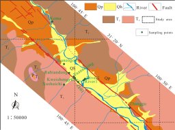 Yuqing Zhao合作论文数Coll Environm Sci & Engn, Guilin Univ Technol2Wei Tao合作论文数2Qiang Li合作论文数2Jiangyi Li合作论文数2
 Shengtao Feng (冯胜涛)合作论文数2GuanZhong Liu (刘冠中)合作论文数2WanZheng Cheng (程万正)合作论文数2ShuangHong Wang (王双洪)合作论文数2JianLing Cao (曹建玲)合作论文数中国地震局地震预测研究所2Hang Zhu (朱航)合作论文数2Feng Long (龙锋)合作论文数2
 Jia Cheng (程佳)合作论文数中国地震台网中心2Wenxin Wei合作论文数2
 Xue-Ze Wen (闻学泽)合作论文数State Key Laboratory of Seismic Dynamics, Institute of Geology, China Earthquake Administration2
 Bengang Zhou (周本刚)合作论文数Institute of Geology, China Earthquake Administration2Ping Xiang (向平)合作论文数2
 Qing-Liang Wang (王庆良)合作论文数The Second Monitoring and Application Center, China Earthquake Administration;Institute of Disaster Prevention2
 Jin Ma (马瑾)合作论文数Institute of Geology, China Earthquake Administration2
 Caijun Xu (许才军)合作论文数Institute of Earthquake Forecasting, China Earthquake Administration;School of Geodesy and Geomatics, Wuhan University2Enning Wang合作论文数University of Science and Technology of China School of Earth and Space Sciences2
 Youkuan Zhang (张幼宽)合作论文数School of Environmental Science and Engineering, Southern University of Science and Technology;Guangdong Provincial Key Laboratory of Soil and Groundwater Pollution Control2Yunma Xu (徐云马)合作论文数2Zhi-gang SHAO (邵志刚)合作论文数1HePing Xiang (和平向)合作论文数1Ze Zhu合作论文数1Zhuhu Huang合作论文数1
 Jiuyuan Yang合作论文数1




