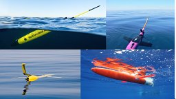
Argo floats have been deployed in the global ocean for over 20 years. The Core mission of the Argo program (Core Argo) has contributed well over 2 million profiles of salinity and temperature of the upper 2000 m of the water column for a variety of operational and scientific applications. Core Argo floats have evolved such that the program currently consists of more than eight types of Core Argo float, some of which belong to second or third generation developments, three unique satellite communication systems (Argos, Iridium and Beidou) and two types of Conductivity, Temperature and Depth (CTD) sensor systems (Seabird and RBR). This, together with a well-established data management system, delayed mode data quality control, FAIR and open data access, make the program a very successful ocean observing network. Here we present Part 1 of the Best Practices for Core Argo floats in terms of how users can get started in the program, recommended metadata parameters and the data management system. The objective is to encourage new and developing scientists, research teams and institutions to contribute to the OneArgo Program, specifically to the Core Argo mission. Only by leveraging sustained contributions from current Core Argo float groups with new and emerging Argo teams and users who are eager to get involved and are actively encouraged to do so, can the OneArgo initiative be realized. This paper presents a list of best practices to get started in the program, set up the recommended metadata, implement the data management system with the aim to encourage new scientists, countries and research teams to contribute to the OneArgo Program.
Following on from Part 1: Best Practices for Core Argo floats - Getting started and data considerations, we present Part 2: Best Practices for Core Argo floats in terms of physical handling and deployments and recommended metadata parameters. The objective is to encourage new and developing scientists, research teams and institutions to contribute to the OneArgo Program through increased deployments regionally, specifically to the Core Argo mission. Only by leveraging sustained contributions of current Core Argo float groups with new and emerging Argo teams and users, can the OneArgo initiative be realized. This paper makes involvement with the Core Argo mission smoother by providing a framework endorsed by a wide community for these observations.
The years since 2000 have been a golden age in in situ ocean observing with the proliferation and organization of autonomous platforms such as surface drogued buoys and subsurface Argo profiling floats augmenting ship-based observations. Global time series of mean sea surface temperature and ocean heat content are routinely calculated based on data from these platforms, enhancing our understanding of the ocean’s role in Earth’s climate system. Individual measurements of meteorological, sea surface, and subsurface variables directly improve our understanding of the Earth system, weather forecasting, and climate projections. They also provide the data necessary for validating and calibrating satellite observations. Maintaining this ocean observing system has been a technological, logistical, and funding challenge. The global COVID-19 pandemic, which took hold in 2020, added strain to the maintenance of the observing system. A survey of the contributing components of the observing system illustrates the impacts of the pandemic from January 2020 through December 2021. The pandemic did not reduce the short-term geographic coverage (days to months) capabilities mainly due to the continuation of autonomous platform observations. In contrast, the pandemic caused critical loss to longer-term (years to decades) observations, greatly impairing the monitoring of such crucial variables as ocean carbon and the state of the deep ocean. So, while the observing system has held under the stress of the pandemic, work must be done to restore the interrupted replenishment of the autonomous components and plan for more resilient methods to support components of the system that rely on cruise-based measurements.
Despite technological advances over the last several decades, ship-based hydrography remains the only method for obtaining high-quality, high spatial and vertical resolution measurements of physical, chemical, and biological parameters over the full water column essential for physical, chemical, and biological oceanography and climate science. The Global Ocean Ship-based Hydrographic Investigations Program (GO-SHIP) coordinates a network of globally sustained hydrographic sections. These data provide a unique data set that spans four decades, comprised of more than 40 cross-ocean transects. The section data are, however, difficult to use owing to inhomogeneous format. The purpose of this new temperature, salinity, and dissolved oxygen data product is to combine, reformat and grid these data measured by Conductivity-Temperature-Depth-Oxygen (CTDO) profilers in order to facilitate their use by a wider audience. The product is machine readable and readily accessible by many existing visualisation and analysis software packages. The data processing can be repeated with modifications to suit various applications such as analysis of deep ocean, validation of numerical simulation, and calibration of autonomous platforms.
In this presentation, we will discuss the procedures and utilities employed that produced the final core data (CTDO, nutrients, salinity, and oxygen). These datasets were published within 4 weeks of the conclusion of the cruise, much quicker than the program's 6-week requirement for preliminary data, and significantly faster than the 6-month final data requirement. The Global Ocean Ship-based Hydrographic Investigations Program (GO-SHIP) “provides approximately decadal resolution of the changes in inventories of heat, freshwater, carbon, oxygen, nutrients, and transient tracers, covering the ocean basins from coast to coast and full depth (top to bottom), with global measurements of the highest required accuracy to detect these changes.” The Oceanographic Data Facility at Scripps Institution of Oceanography has been making the CTDO, salinity, oxygen, and nutrient measurements since the program's inception for some of the US lead GO-SHIP expeditions. This group internally shares personnel with the corresponding data repository (CCHDO). This collaboration allows the technicians to proactively develop tools and data formats that are both compliant for data submission as well as easy to utilize at sea. Mature versions of these utilities and procedures were promoted in both 1-on-1 conversations and interactive demonstrations. The most recent set of measurements made by the US GO-SHIP program was in the Atlantic ocean last year (March-May 2021). Taking advantage of existing close collaborations within the shipboard environment, we were able to ensure measurements were documented while the expedition was still in progress, ensuring that data formats were consistent and conforming to the program's required formats. A full metadata package for the global/cross-cruise database, in addition to mature preliminary files, was ready at the conclusion of the expedition. The close relationship between the seagoing team and the data managers in the repository has allowed for the accelerated publication of finalized measurements through sharing of software, metadata databases, and expertise.
The needs of society and the emerging blue economy require access and integration of data and information for the construction of dedicated products. A "transparent and accessible ocean" is one of the key objectives of the Ocean Decade 2021–30. In this context, marine infrastructures become significant components of a global knowledge environment, enabling environmental assessment and providing the necessary data for scientifically valid actions to protect and restore ocean health, to use marine resources in a sustainable way. The data is collected, analyzed, organized, and used by people and their good use/reuse can be obtained with social practices, technological and physical agreements aimed at facilitating collaborative knowledge, decision-making, inference. The vision is a digital ocean data ecosystem made up of multiple, interoperable, and scalable components. The huge amount of data and the resulting products can drive the development of new knowledge as well as new applications and services. Predictive capabilities that derive from the digital ecosystem enable the implementation of services for real-time decision-making, multihazard warning systems, and advance marine space planning. The chapter develops following the progressive complexity and information content of products deriving from oceanic data: data cycle and data collections, data products, oceanic reanalysis. The chapter discusses the new challenges of data products and the complexity of deriving them.
Earth and Space Science Open Archive Presented WorkOpen AccessYou are viewing the latest version by default [v1]Why Access to Data Matters and What We Can Do to Improve Access and ReusabilityAuthorsDeniseHillsStephenDiggsSee all authors Denise HillsCorresponding Author• Submitting AuthorGeological Survey of Alabama,University of Alabamaview email addressThe email was not providedcopy email addressStephen DiggsUniversity of California San Diego Scripps Institution of Oceanographyview email addressThe email was not providedcopy email address
Despite numerous technological advances over the last several decades, ship-based hydrography remains the only method for obtaining high-quality, high spatial and vertical resolution measurements of a suite of physical, chemical, and biological parameters over the full water column essential for physical, chemical, and biological oceanography and climate science. The Global Ocean Ship-based Hydrographic Investigations Program (GO-SHIP) coordinates a network of globally sustained hydrographic sections as part of the global ocean observing system, building on previous programs. These data provide a unique data set that spans four decades, comprised of more than 40 cross-ocean transects, many with multiple repeats. The section data are, however, difficult to use owing to inhomogeneous format. The purpose of this data product is to increase the value of these data by better combining, reformatting and gridding in order to facilitate their use with less effort by a wider audience. The product is machine readable and readily accessible by many existing visualisation and analysis software packages. The data processing can be repeated with modifications to suit various applications such as analysis of deep ocean , validation of numerical simulation output, and calibration of autonomous platforms. This initial release includes temperature, salinity, and dissolved oxygen data from Conductivity-Temperature-Depth profiles, but the product will include other properties in future releases.
The ocean is mitigating global warming by absorbing large amounts of excess carbon dioxide from human activities. To quantify and monitor the ocean carbon sink, we need a state-of-the-art data resource that makes data submission and retrieval machine-compatible and efficient.
Given the expected increase in demand for Data Stewards and Data Stewardship skills it is clear that there is a need to develop training, education and CPD (continuous professional development) in this area.In this paper a brief introduction is provided to the origin of definitions of Data Stewardship. Also it notes the present tendency towards equivalence between Data Stewardship skills and FAIR principles. It then focuses on one specific training event – the pilot Data Stewardship strand of the CODATA-RDA Research Data Science schools that by the time of the IDCC meeting will have been held in Trieste in August 2019. The paper will discuss the overall curriculum for the pilot school, how it matches with the FAIR4S framework, and plans for getting feedback from the students.Finally, the paper discuss future plans for the school, in particular how to deepen the integration between the Data Stewardship strand with the Early Career Researcher strand.
Finding and integrating geoscience data that are fit for use can alter the scope and even the type of science exploration undertaken. Most of these difficulties in data discovery and use are due to a technical incompatibilities in the various data repositories that comprise the data system for a particular scientific problem. We believe these obstacles to be unnecessary attributes of individual data centers that were created more than 20 years ago. This aspirational presentation charts a new way forward for data curators and users alike, and by employing technical advances in adjacent disciples, promises a new era of scientific discovery enabled by re-envisioned 21st century data repositories.
Well-founded data management systems are of vital importance for ocean observing systems as they ensure that essential data are not only collected but also retained and made accessible for analysis and application by current and future users. Effective data management requires collaboration across activities including observations, metadata and data assembly, quality assurance and control (QA/QC), and data publication that enables local and interoperable discovery and access and secures archiving that guarantees long-term preservation. To achieve this, data should be findable, accessible, interoperable, and reusable (FAIR). Here, we outline how these principles apply to ocean data and illustrate them with a few examples. In recent decades, ocean data managers, in close collaboration with international organizations, have played an active role in the improvement of environmental data standardization, accessibility, and interoperability through different projects, enhancing access to observation data at all stages of the data life cycle and fostering the development of integrated services targeted to research, regulatory, and operational users. As ocean observing systems evolve and an increasing number of autonomous platforms and sensors are deployed, the volume and variety of data increase dramatically. For instance, there are more than 70 data catalogs that contain metadata records for the polar oceans, a situation that makes comprehensive data discovery beyond the capacity of most researchers. To better serve research, operational, and commercial users, more efficient turnaround of quality data in known formats and made available through Web services is necessary. In particular, automation of data workflows will be critical to reduce friction throughout the data value chain. Adhering to the FAIR principles with free, timely, and unrestricted access to ocean observation data is beneficial for the originators, has obvious benefits for users, and is an essential foundation for the development of new services made possible with big data technologies.
The Global Ocean Ship-Based Hydrographic Investigations Program (GO-SHIP) provides a globally coordinated network and oversight of 55 sustained decadal repeat hydrographic reference lines. GO-SHIP is part of the global ocean/climate observing systems (GOOS/GCOS) for study of physical oceanography, the ocean carbon, oxygen and nutrient cycles, and marine biogeochemistry. GO-SHIP enables assessment of the ocean sequestration of heat and carbon, changing ocean circulation and ventilation patterns, and their effects on ocean health and Earth's climate. Rapid quality control and open data release along with incorporation of the GO-SHIP effort in the Joint Technical Commission for Oceanography and Marine Meteorology (JCOMM) in situ Observing Programs Support Center (JCOMMOPS) have increased the profile of, and participation in, the program and led to increased data use for a range of efforts. In addition to scientific discovery, GO-SHIP provides climate quality observations for ongoing calibration of measurements from existing and new autonomous platforms. This includes biogeochemical observations for the nascent array of biogeochemical (BGC)-Argo floats; temperature and salinity for Deep Argo; and salinity for the core Argo array. GO-SHIP provides the relevant suite of global, full depth, high quality observations and co-located deployment opportunities that, for the foreseeable future, remain crucial to maintenance and evolution of Argo's unique contribution to climate science. The evolution of GO-SHIP from a program primarily focused on physical climate to increased emphasis on ocean health and sustainability has put an emphasis on the addition of essential ocean variables for biology and ecosystems in the program measurement suite. In conjunction with novel automated measurement systems, ocean color, particulate matter, and phytoplankton enumeration are being explored as GO-SHIP variables. The addition of biological and ecosystem measurements will enable GO-SHIP to determine trends and variability in these key indicators of ocean health. The active and adaptive community has sustained the network, quality and relevance of the global repeat hydrography effort through societally important scientific results, increased exposure, and interoperability with new efforts and opportunities within the community. Here we provide key recommendations for the continuation and growth of GO-SHIP in the next decade.
The Southern Ocean is disproportionately important in its effect on the Earth system, impacting climatic, biogeochemical and ecological systems, which makes recent observed changes to this system cause for global concern. The enhanced understanding and improvements in predictive skill needed for understanding and projecting future states of the Southern Ocean require sustained observations. Over the last decade, the Southern Ocean Observing System (SOOS) has established networks for enhancing regional coordination and research community groups to advance development of observing system capabilities. These networks support delivery of the SOOS 20-year vision, which is to develop a circumpolar system that ensures time series of key variables, and deliver the greatest impact from data to all key end-users. Although the Southern Ocean remains one of the least-observed ocean regions, enhanced international coordination and advances in autonomous platforms have resulted in progress towards addressing the need for sustained observations of this region. Since 2009, the Southern Ocean community has deployed over 5700 observational platforms south of 40°S. Large-scale, multi-year or sustained, multidisciplinary efforts have been supported and are now delivering observations of essential variables at space and time scales that enable assessment of changes being observed in Southern Ocean systems. The improved observational coverage, however, is predominantly for the open ocean, encompasses the summer, consists of primarily physical oceanographic variables and covers surface to 2000 m. Significant gaps remain in observations of the ice-impacted ocean, the sea ice, depths more than 2000 m, the air-sea-ice interface, biogeochemical and biological variables, and for seasons other than summer. Addressing these data gaps in a sustained way requires parallel advances in coordination networks, cyberinfrastructure and data management tools, observational platform and sensor technology, platform interrogation and data-transmission technologies, modeling frameworks, and internationally agreed sampling requirements of key variables. This paper presents a community statement on the major scientific and observational progress of the last decade, and importantly, an assessment of key priorities for the coming decade, towards achieving the SOOS vision and delivering essential data to all end users.
Diapycnal mixing plays a primary role in the thermodynamic balance of the ocean and, consequently, in oceanic heat and carbon uptake and storage. Though observed mixing rates are on average consistent with values required by inverse models, recent attention has focused on the dramatic spatial variability, spanning several orders of magnitude, of mixing rates in both the upper and deep ocean. Away from ocean boundaries, the spatio-temporal patterns of mixing are largely driven by the geography of generation, propagation and dissipation of internal waves, which supply much of the power for turbulent mixing. Over the last five years and under the auspices of US CLIVAR, a NSF- and NOAA-supported Climate Process Team has been engaged in developing, implementing and testing dynamics-based parameterizations for internal-wave driven turbulent mixing in global ocean models. The work has primarily focused on turbulence 1) near sites of internal tide generation, 2) in the upper ocean related to wind-generated near inertial motions, 3) due to internal lee waves generated by low-frequency mesoscale flows over topography, and 4) at ocean margins. Here we review recent progress, describe the tools developed, and discuss future directions.
 Lynne D. Talley合作论文数Scripps Institution of Oceanography, University of California, San Diego7
 Danie Kinkade合作论文数Woods Hole Oceanographic Institution5
 Bernadette Sloyan合作论文数CSIRO4Katsuro Katsumata合作论文数4Martin Kramp合作论文数3
 Victor Turpin合作论文数OceanOPS Joint WMO IOC Ctr Oceanog & Marine Meteo3James Swift合作论文数3
 Sarah Purkey合作论文数Scripps Institution of Oceanography, University of California, San Diego3
 Rebecca Cowley合作论文数CSIRO, Commonwealth Scientific and Industrial Research Organization3
 B. Pfeil合作论文数Sektion Physik der Universität München Theresienstrasse 37 D-8000 Munich 2 Germany Theresienstrasse 37 D-8000 Munich 2 Germany3Alex Kozyr合作论文数3
 Kenneth S Casey合作论文数3
 Richard (Rik) Wanninkhof合作论文数NOAA's Atlantic Oceanographic and Meteorological Laboratory, U.S. Department of Commerce3
 Toste Tanhua合作论文数3Breck Owens合作论文数2Mathieu Belbeoch合作论文数2Noe Poffa合作论文数2Eugene F. Burger合作论文数2
 Jessica Hausman合作论文数2Kevin O'Brien合作论文数2Megan Scanderbeg合作论文数2michael j m williams合作论文数Natl Inst Water & Atmospher Res NIWA2
 Tamaryn Morris合作论文数South African Environm Observat Network Egagasini2
 Thomas S. Moore合作论文数CSIRO Oceans & Atmosphere, Hobart, Tas, Australia2
 Gustavo Jorge Goñi合作论文数United States Department of Commerce, Atlantic Oceanographic and Meteorological Laboratory, National Oceanic and Atmospheric Administration2Tim P. Boyer合作论文数2Akihiko Murata合作论文数2
 Emil Jeansson合作论文数Department of Chemistry, Göteborg University2
 Anton Pieter Van de Putte合作论文数2
 Jan Marinus Hoppema合作论文数Helmholtz Centre for Polar and Marine Research, Alfred Wegener Institute;Department Physical Oceanography of Polar Seas, Alfred Wegener Institute;University of Applied Sciences Bremerhaven2
 Erin Robinson合作论文数Lantern Corporation;Washington University;Lantern Corporation, Washington University2
 Zenghong Liu (刘增宏)合作论文数State Key Laboratory of Satellite Ocean Environment Dynamics, Second Institute of Oceanography, Ministry of Natural Resources2
 Fiz Fernández Pérez合作论文数Instituto de Investigaciones Marinas de Vigo2Karen Stocks合作论文数San Diego Supercomputer Center, University of California San Diego2
 Claire Gourcuff合作论文数2
 Masao Ishii (石井雅男)合作论文数Department of Climate and Geochemistry Research, Meteorological Research Institute2Alison R. Gray合作论文数1Martin Morahan合作论文数1Jae Hak Lee合作论文数1T. De Bruin合作论文数1Peter J. Brown合作论文数1Ann Thresher合作论文数1Andrew Barna合作论文数1Kenneth J. Connell合作论文数1Andrew I. Pickering合作论文数1Peter Thijsse合作论文数1Benjamin Mater合作论文数1Giuseppe Manzella合作论文数1Joana Beja合作论文数1




