Information on tropical Asian vertebrates has traditionally been sparse, particularly when it comes to cryptic species inhabiting the dense forests of the region. Vertebrate populations are declining globally due to land-use change and hunting, the latter frequently referred as "defaunation." This is especially true in tropical Asia where there is extensive land-use change and high human densities. Robust monitoring requires that large volumes of vertebrate population data be made available for use by the scientific and applied communities. Camera traps have emerged as an effective, non-invasive, widespread, and common approach to surveying vertebrates in their natural habitats. However, camera-derived datasets remain scattered across a wide array of sources, including published scientific literature, gray literature, and unpublished works, making it challenging for researchers to harness the full potential of cameras for ecology, conservation, and management. In response, we collated and standardized observations from 239 camera trap studies conducted in tropical Asia. There were 278,260 independent records of 371 distinct species, comprising 232 mammals, 132 birds, and seven reptiles. The total trapping effort accumulated in this data paper consisted of 876,606 trap nights, distributed among Indonesia, Singapore, Malaysia, Bhutan, Thailand, Myanmar, Cambodia, Laos, Vietnam, Nepal, and far eastern India. The relatively standardized deployment methods in the region provide a consistent, reliable, and rich count data set relative to other large-scale pressence-only data sets, such as the Global Biodiversity Information Facility (GBIF) or citizen science repositories (e.g., iNaturalist), and is thus most similar to eBird. To facilitate the use of these data, we also provide mammalian species trait information and 13 environmental covariates calculated at three spatial scales around the camera survey centroids (within 10-, 20-, and 30-km buffers). We will update the dataset to include broader coverage of temperate Asia and add newer surveys and covariates as they become available. This dataset unlocks immense opportunities for single-species ecological or conservation studies as well as applied ecology, community ecology, and macroecology investigations. The data are fully available to the public for utilization and research. Please cite this data paper when utilizing the data.
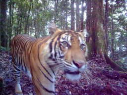
Southeast Asia experiences some of the highest deforestation in the world. Loss of tropical forest typically leads to widespread habitat fragmentation, with detrimental effects on dispersal ability and gene flow—particularly for large carnivores. We conducted mtDNA and microsatellite analysis to assess—for the first time—contemporary patterns of genetic diversity in the Malayan tiger. We collected 295 suspected carnivore samples in Peninsular Malaysia, from which we identified 26 as originating from tiger using 16 polymorphic microsatellite loci, comprising 22 individual tigers. Despite limitations of the study, our findings suggest tiger subpopulations in the north of the peninsula maintain some genetic connectivity and migration between two putative geographic subpopulations in the Main Range and Greater Taman Negara, with negligible population segregation due to dispersal barriers such as road infrastructure. We identified consistently lower levels of genetic diversity in tigers in the Greater Taman Negara region compared to tigers in the Main Range and small but emerging differences in nuclear and mitochondrial genetic diversity. Our mtDNA haplotype and nuclear DNA analyses suggest the levels of genetic diversity in Malayan tigers may be amongst some of the lowest of the surviving tiger subspecies, though the study is limited both in scale and genomic loci. Our findings are consistent with an expected lag between the rapid decline of tigers in Peninsular Malaysia by over 95% in the last 70 years and observed differences in their levels of genetic diversity.
Abstract Dhole (Cuon alpinus) is threatened with extinction across its range due to habitat loss and prey depletion. Despite this, no previous study has investigated the distribution and threat of the species at a regional scale. This lack of knowledge continues to impede conservation planning for the species. Here we modeled suitable habitat using presence‐only camera trap data for dhole and dhole prey species in mainland Southeast Asia and assessed the threat level to dhole in this region using an expert‐informed Bayesian Belief Network. We integrated prior information to identify dhole habitat strongholds that could support populations over the next 50 years. Our habitat suitability model identified forest cover and prey availability as the most influential factors affecting dhole occurrence. Similarly, our threat model predicted that forest loss and prey depletion were the greatest threats, followed by local hunting, non‐timber forest product collection, and domestic dog incursion into the forest. These threats require proactive resource management, strong legal protection, and cross‐sector collaboration. We predicted <20% of all remaining forest cover in our study area to be suitable for dhole. We then identified 17 patches of suitable forest area as potential strongholds. Among these patches, Western Forest Complex (Thailand) was identified as the region's only primary stronghold, while Taman Negara (Malaysia), and northeastern landscape (Cambodia) were identified as secondary strongholds. Although all 17 patches met our minimum size criteria (1667 km2), patches smaller than 3333 km2 may require site management either by increasing the ecological carrying capacity (i.e., prey abundance) or maintaining forest extent. Our proposed interventions for dhole would also strengthen the conservation of other co‐occurring species facing similar threats. Our threat assessment technique of species with scarce information is likely replicable with other endangered species.
Identifying conservation priorities for an understudied species can be challenging, as the amount and type of data available to work with are often limited. Here, we demonstrate a flexible workflow for identifying priorities for such data-limited species, focusing on the little-studied Asian golden cat (Catopuma temminckii) in mainland Tropical Asia. Using recent occurrence records, we modeled the golden cat’s expected area of occurrence and identified remaining habitat strongholds (i.e., large intact areas with moderate-to-high expected occurrence). We then classified these strongholds by recent camera-trap survey status (from a literature review) and near-future threat status (based on publicly available forest loss projections and Bayesian Belief Network derived estimates of hunting-induced extirpation risk) to identify conservation priorities. Finally, we projected the species’ expected area of occurrence in the year 2000, approximately three generations prior to today, to define past declines and better evaluate the species’ current conservation status. Lower levels of hunting-induced extirpation risk and higher levels of closed-canopy forest cover were the strongest predictors of recent camera-trap records. Our projections suggest a 68% decline in area with moderate-to-high expected occurrence between 2000 and 2020, with a further 18% decline predicted over the next 20 years. Past and near-future declines were primarily driven by cumulatively increasing levels of hunting-induced extirpation risk, suggesting assessments of conservation status based solely on declines in habitat may underestimate actual population declines. Of the 40 remaining habitat strongholds, 77.5% were seriously threatened by forest loss and hunting. Only 52% of threatened strongholds had at least one site surveyed, compared to 100% of low-to-moderate threat strongholds, thus highlighting an important knowledge gap concerning the species’ current distribution and population status. Our results suggest the golden cat has experienced, and will likely continue to experience, considerable population declines and should be considered for up-listing to a threatened category (i.e., VU/EN) under criteria A2c of the IUCN Red List.
Deforestation is a major threat to terrestrial tropical ecosystems, particularly in Southeast Asia where human activities have dramatic consequences for the survival of many species. However, responses of species to anthropogenic impact are highly variable. In order to establish effective conservation strategies, it is critical to determine a species’ ability to persist in degraded habitats. Here, we used camera trapping data to provide the first insights into the temporal and spatial distribution of southern pig-tailed macaques (Macaca nemestrina, listed as ‘Vulnerable’ by the IUCN) across intact and degraded forest habitats in Peninsular Malaysia, with a particular focus on the effects of clear-cutting and selective logging on macaque occupancy. Specifically, we found a 10% decline in macaque site occupancy in the highly degraded Pasoh Forest Reserve from 2013 to 2017. This may be strongly linked to the macaques’ sensitivity to intensive disturbance through clear-cutting, which significantly increased the probability that M. nemestrina became locally extinct at a previously occupied site. However, we found no clear relationship between moderate disturbance, i.e., selective logging, and the macaques’ local extinction probability or site occupancy in the Pasoh Forest Reserve and Belum-Temengor Forest Complex. Further, an identical age and sex structure of macaques in selectively logged and completely undisturbed habitat types within the Belum-Temengor Forest Complex indicated that the macaques did not show increased mortality or declining birth rates when exposed to selective logging. Overall, this suggests that low to moderately disturbed forests may still constitute valuable habitats that support viable populations of M. nemestrina, and thus need to be protected against further degradation. Our results emphasize the significance of population monitoring through camera trapping for understanding the ability of threatened species to cope with anthropogenic disturbance. This can inform species management plans and facilitate the development of effective conservation measures to protect biodiversity.
Across the tropics, large-bodied mammals have been affected by selective logging in ways that vary with levels of timber extraction, collateral damage, species-specific traits and secondary effects of hunting, as facilitated by improved access through logging roads. In Peninsular Malaysia, 3.0 million hectares or 61 percent of its Permanent Reserved Forests is officially assigned for commercial selective logging. Understanding how wildlife adapts and uses logged forest is critical for its management and, for threatened species, their conservation. In this study, we quantify the population status of four tropical ungulate species in a large selectively logged forest reserve and an adjacent primary forest protected area. We then conduct finer scale analyses to identify the species-specific factors that determine their occurrence. A combined indirect sign-camera trapping approach with a large sampling effort (2,665 km and 27,780 trap nights surveyed) covering a wide area (560 km 2 ) generated species-specific detection probabilities and site occupancies. Populations of wild boar were widespread across both logged and primary forests, whereas sambar and muntjac occupancy was lower in logged forest (48.4% and 19.2% respectively), with gaur showing no significant difference. Subsequent modelling revealed the importance of conserving lower elevation habitat in both habitat types, particularly <1,000 m asl, for which occupancies of sambar, muntjac and gaur were typically higher. This finding is important because 75 percent (~13,400 km 2 ) of Peninsular Malaysia’s Main Range Forest (Banjaran Titiwangsa) is under 1,000 m asl and therefore at risk of being converted to industrial timber plantations, which calls for renewed thinking around forest management planning.
Rates of biodiversity loss in Southeast Asia are among the highest in the world, and the Indo-Burma and South-Central China Biodiversity Hotspots rank among the world’s most threatened. Developing robust multi-species conservation models is critical for stemming biodiversity loss both here and globally. We used a large and geographically extensive remote-camera survey and multi-scale, multivariate optimization species distribution modelling to investigate the factors driving biodiversity across these two adjoining biodiversity hotspots. Four major findings emerged from the work. (i) We identified clear spatial patterns of species richness, with two main biodiverse centres in the Thai-Malay Peninsula and in the mountainous region of Southwest China. (ii) Carnivores in particular, and large ungulates to a lesser degree, were the strongest indicators of species richness. (iii) Climate had the largest effect on biodiversity, followed by protected status and human footprint. (iv) Gap analysis between the biodiversity model and the current system of protected areas revealed that the majority of areas supporting the highest predicted biodiversity are not protected. Our results highlighted several key locations that should be prioritized for expanding the protected area network to maximize conservation effectiveness. We demonstrated the importance of switching from single-species to multi-species approaches to highlight areas of high priority for biodiversity conservation. In addition, since these areas mostly occur over multiple countries, we also advocate for a paradigmatic focus on transboundary conservation planning.
Aim Deforestation is rapidly altering Southeast Asian landscapes, resulting in some of the highest rates of habitat loss worldwide. Among the many species facing declines in this region, clouded leopards rank notably for their ambassadorial potential and capacity to act as powerful levers for broader forest conservation programmes. Thus, identifying core habitat and conservation opportunities are critical for curbing further Neofelis declines and extending umbrella protection for diverse forest biota similarly threatened by widespread habitat loss. Furthermore, a recent comprehensive habitat assessment of Sunda clouded leopards (N. diardi) highlights the lack of such information for the mainland species (N. nebulosa) and facilitates a comparative assessment. Location Southeast Asia. Methods Species-habitat relationships are scale-dependent, yet <5% of all recent habitat modelling papers apply robust approaches to optimize multivariate scale relationships. Using one of the largest camera trap datasets ever collected, we developed scale-optimized species distribution models for two con-generic carnivores, and quantitatively compared their habitat niches. Results We identified core habitat, connectivity corridors, and ranked remaining habitat patches for conservation prioritization. Closed-canopy forest was the strongest predictor, with similar to 25% lower Neofelis detections when forest cover declined from 100 to 65%. A strong, positive association with increasing precipitation suggests ongoing climate change as a growing threat along drier edges of the species' range. While deforestation and land use conversion were deleterious for both species, N. nebulosa was uniquely associated with shrublands and grasslands. We identified 800 km(2) as a minimum patch size for supporting clouded leopard conservation. Main conclusions We illustrate the utility of multi-scale modelling for identifying key habitat requirements, optimal scales of use and critical targets for guiding conservation prioritization. Curbing deforestation and development within remaining core habitat and dispersal corridors, particularly in Myanmar, Laos and Malaysia, is critical for supporting evolutionary potential of clouded leopards and conservation of associated forest biodiversity.
With less than 3200 wild tigers in 2010, the heads of 13 tiger-range countries committed to doubling the global population of wild tigers by 2022. This goal represents the highest level of ambition and commitment required to turn the tide for tigers in the wild. Yet, ensuring efficient and targeted implementation of conservation actions alongside systematic monitoring of progress towards this goal requires that we set site-specific recovery targets and timelines that are ecologically realistic. In this study, we assess the recovery potential of 18 sites identified under WWF's Tigers Alive Initiative. We delineated recovery systems comprising a source, recovery site, and support region, which need to be managed synergistically to meet these targets. By using the best available data on tiger and prey numbers, and adapting existing species recovery frameworks, we show that these sites, which currently support 165 (118-277) tigers, have the potential to harbour 585 (454-739) individuals. This would constitute a 15% increase in the global population and represent over a three-fold increase within these specific sites, on an average. However, it may not be realistic to achieve this target by 2022, since tiger recovery in 15 of these 18 sites is contingent on the initial recovery of prey populations, which is a slow process. We conclude that while sustained conservation efforts can yield significant recoveries, it is critical that we commit our resources to achieving the biologically realistic targets for these sites even if the timelines are extended.
Ongoing deforestation in Southeast Asia is leading to increased fragmentation and reduction of habitat for the mainland clouded leopard (Neofelis nebulosa). Using the largest detection/non-detection camera trap survey dataset known for the species throughout its range, we investigated factors affecting clouded leopard habitat use across Peninsular Malaysia. Habitat use was modelled using fine scale covariates and recently developed analytical techniques to account for spatial autocorrelation. Clouded leopard habitat use increased with increasing distance from water bodies, higher numbers of discontinuous core areas per unit area and higher elevation. In addition, clouded leopard habitat use was higher in sites with higher average forest change values. After extrapolating the predicted habitat use of clouded leopards across the whole of Peninsular Malaysia, we assessed the suitability of proposed ecological linkages, and identified other suitable forest patches not within the current Central Forest Spine. Our findings are valuable for land use planning and management, in particular, for determining the suitability of forest remnants to support populations of clouded leopard and predicting how this species will respond in human-dominated landscapes.
Managing populations of large carnivore species that are threatened yet in competition with each other presents a conservation challenge over which species to prioritise. We investigated interspecific competition between the Endangered tiger and two sympatric carnivore species (Near-Threatened leopard and Endangered dhole) in Malaysia. We used a spatially-explicit camera trapping method to sample the three carnivore species in order to assess their: relative abundance; spatial co-occurrence; and, temporal overlap. Our focal landscape consists of two adjacent study areas that have different forest management regimes: 1) Royal Belum State Park (RBSP) which has relatively higher levels of enforcement resulting in high tiger and prey densities, and 2) Temengor Forest Reserve (TFR) which has no enforcement resulting in low tiger and prey densities. Our analyses found interspecific competition in the form of fine-scale spatial avoidance of tiger by leopard in RBSP, but not in TFR. Thus, leopard was less likely to occur in forest patches with greater tiger presence in RBSP. Dhole was not detected in RBSP, and showed no fine-scale spatial avoidance of tiger on TRF. It was unclear if absence of dhole in RBSP was due to the high tiger density, or another factor such as disease. Regardless, our results indicate dhole can persist in human-degraded forest landscapes. Neither leopards nor dholes showed any major temporal avoidance of tigers on either site. Our findings of fine-scale spatial avoidance by leopard towards tiger and possible exclusion of dhole by tiger in areas of high tiger density were similar to that found in other areas of Asia. Our study demonstrates that degraded forest can be important for threatened carnivores. It also provides a reminder that efforts to recover tiger populations, a conservation priority, may require flanking measures to secure meso-predator populations, especially those forced into edge environments where they come into greater contact with people.
Background. The bay cat Catopuma badia is endemic to Borneo, whereas its sister species the Asian golden cat Catopuma temminckii is distributed from the Himalayas and southern China through Indochina, Peninsular Malaysia and Sumatra. Based on morphological data, up to five subspecies of the Asian golden cat have been recognized, but a taxonomic assessment, including molecular data and morphological characters, is still lacking. Results. We combined molecular data (whole mitochondrial genomes), morphological data (pelage) and species distribution projections (up to the Late Pleistocene) to infer how environmental changes may have influenced the distribution of these sister species over the past 120 000 years. The molecular analysis was based on sequenced mitogenomes of 3 bay cats and 40 Asian golden cats derived mainly from archival samples. Our molecular data suggested a time of split between the two species approximately 3.16 million years and revealed very low nucleotide diversity within the Asian golden cat population, which supports recent expansion of the population. Discussion. The low nucleotide diversity suggested a population bottleneck in the Asian golden cat, possibly caused by the eruption of the Toba volcano in Northern Sumatra (approx. 74 kya), followed by a continuous population expansion in the Late Pleistocene/Early Holocene. Species distribution projections, the reconstruction of the demographic history, a genetic isolation-by-distance pattern and a gradual variation of pelage pattern support the hypothesis of a post-Toba population expansion of the Asian golden cat from south China/Indochina to the Peninsular Malaysia and Sumatra. Our findings reject the current classification of five subspecies for the Asian golden cat, but instead support either a monotypic species or one comprising two subspecies: (i) the Sunda golden cat, distributed south of the Isthmus of Kra: C. t. temminckii and (ii) Indochinese, Indian, Himalayan and Chinese golden cats, occurring north of the Isthmus: C. t. moormensis.
Background. The bay cat Catopuma badia is endemic to Borneo, whereas its sister species the Asian golden cat Catopuma temminckii is distributed from the Himalayas and southern China through Indochina, Peninsular Malaysia and Sumatra. Based on morphological data, up to five subspecies of the Asian golden cat have been recognized, but a taxonomic assessment, including molecular data and morphological characters, is still lacking. Results. We combined molecular data (whole mitochondrial genomes), morphological data (pelage) and species distribution projections (up to the Late Pleistocene) to infer how environmental changes may have influenced the distribution of these sister species over the past 120 000 years. The molecular analysis was based on sequenced mitogenomes of 3 bay cats and 40 Asian golden cats derived mainly from archival samples. Our molecular data suggested a time of split between the two species approximately 3.16 Ma and revealed very low nucleotide diversity within the Asian golden cat population, which supports recent expansion of the population. Discussion. The low nucleotide diversity suggested a population bottleneck in the Asian golden cat, possibly caused by the eruption of the Toba volcano in Northern Sumatra (approx. 74 kya), followed by a continuous population expansion in the Late Pleistocene/Early Holocene. Species distribution projections, the reconstruction of the demographic history, a genetic isolation-by-distance pattern and a gradual variation of pelage pattern support the hypothesis of a post-Toba population expansion of the Asian golden cat from south China/Indochina to Peninsular Malaysia and Sumatra. Our findings reject the current classification of five subspecies for the Asian golden cat, but instead support either a monotypic species or one comprising two subspecies: (i) the Sunda golden cat, distributed south of the Isthmus of Kra: C. t. temminckii and (ii) Indochinese, Indian, Himalayan and Chinese golden cats, occurring north of the Isthmus: C. t. moormensis.
To date, leopards (Panthera pardus) in Peninsular Malaysia have been overlooked by large carnivore researchers. This is in part due to the country's unique population of individuals that are almost all melanistic, which makes it nearly impossible to identify individuals using camera traps for estimating leopard density. We discovered a novel modification to infrared flash camera traps, which forces the camera into night mode, that allows us to consistently and clearly see the spots of a melanistic leopard. The aim of this project was 1) to determine the feasibility of identifying melanistic leopards with confidence using infrared flash camera traps, and 2) to establish a density estimate for the leopard population in a wildlife corridor in Malaysia using maximum likelihood and Bayesian spatially explicit capture-recapture (SECR) models. Both SECR approaches yielded a leopard density of approximately 3 individuals/100km(2). Our estimates represent the first density estimate of leopards in Malaysia and arguably, the world's first successful attempt to estimate the population size of a species with melanistic phenotypes. Because we have demonstrated that melanistic leopards can be monitored with confidence using infrared cameras, future studies should employ our approach instead of relying on scars or body shape for identification. Ultimately, our approach can facilitate more accurate assessments of leopard population trends, particularly in regions where melanistic phenotypes largely occur. (c) 2015 The Wildlife Society.
The mainland clouded leopard (Neofelis nebulosa) is classified as vulnerable under the IUCN Red List, meaning that it faces a high risk of extinction in the wild. However, hardly any ecological research has been published on this species apart from several radiotelemetry studies in Thailand and Nepal, and one camera-trapping study in India. Here we present findings on the clouded leopard from a camera-trapping study conducted in Temengor forest reserve (a logged-over forest) and Royal Belum State Park (a primary forest) within Peninsular Malaysia. Using the spatially-explicit capture-recapture method, the density from Temengor forest reserve and Royal Belum State Park was estimated at 3.46 ± SE 1.00 and 1.83 ± SE 0.61, respectively. Clouded leopard habitat use was found to be highly influenced by the availability of small and medium prey species and therefore intrinsically highlights the potential conservation importance of species such as pig-tailed macaques, porcupine, mouse deer and small carnivores. These findings provide the first estimates of density and habitat use of this species in a logged-primary forest from both Peninsular Malaysia and South East Asia. Our study provides important baseline information on clouded leopards and contributes to filling up the knowledge gap that exists in understanding the population ecology of this species, not only within Peninsular Malaysia, but also on a regional level.
The unprecedented economic growth occurring across Southeast Asia is causing large tracts of rainforest to be logged, converted to plantations or fragmented by infrastructure development. It also opens up forest to poachers which, in combination, places acute pressure on the region's large carnivores. Here, we focus on one of Malaysia's three priority tiger landscapes that illustrate these regional conservation challenges. The Royal Belum State Park (RBSP) and Temengor Forest Reserve (TFR) are connected by a strip of unprotected forest with portions assigned for conversion to monoculture plantations. To support government in setting aside wildlife corridors, we assessed: the abundance of tiger and principle prey under two different forest management regimes in RBSP and TFR; and, tiger habitat use in the unprotected forest strip, from which a spatially-explicit habitat model was produced to identify priority points of forest connectivity. Camera trapping revealed a threefold higher tiger density in the protected area (RBSP) than the forest reserve subjected to selective logging (TFR), which was likely explained by the higher relative abundance of its principal prey, seemingly lower levels of poaching as indicated from an independent study and presence of armed forces that may have deterred poachers. Two forest corridors were identified as being important for maintaining landscape connectivity and these findings were used to successfully lobby state government in affording them protection. This research offers an urgently needed approach for better managing Malaysian tiger habitat within forest reserves, which are predominantly designated for logging and have weak or non-existent wildlife protection measures. (C) 2015 Elsevier Ltd. All rights reserved.
 Gopalasamy Reuben Clements合作论文数Ctr Trop Environm & Sustainabil Sci TESS, James Cook Univ10
 Shariff Wan Mohamad合作论文数8Kae Kawanishi合作论文数8
 Matthew Linkie合作论文数Fauna & Flora International (FFI) in Aceh7
 Dusit Ngoprasert合作论文数5Robert Steinmetz合作论文数5
 Jonathan Moore合作论文数4Laurie Hedges合作论文数4
 Jose Ahimsa Campos Arceiz合作论文数Xishuangbanna Tropical Botanical Garden, Chinese Academy of Sciences;University of Chinese Academy of Sciences4
 Cedric K W Tan合作论文数4
 Andreas Wilting合作论文数Biocentre, University of Würzburg4Riddhi P. Patel合作论文数3Mohamed Shariff W.合作论文数3Hans Pfestorf合作论文数3Thomas N. E. Gray合作论文数3Christopher Chai Thiam Wong合作论文数3Gilmoore Bolongon合作论文数3Dorina Lenz合作论文数3Laura Werner合作论文数3Carl Traeholt合作论文数3Melvin Gumal合作论文数3Jamie Wadey合作论文数College of Science, Health, Engineering and Education, Murdoch University3
 Eric Ash合作论文数Freeland Fdn, Bangkok, Thailand3
 David Macdonald合作论文数Department of Biology, University of Oxford3
 Förster Daniel W合作论文数Evolutionary Genetics Department, Leibniz-Institute for Zoo and Wildlife Research3Hearn Andrew J合作论文数3
 Joerns Fickel合作论文数Institute for Zoo and Wildlife Research3
 Nay myo Shwe合作论文数Department of Forestry, West Gyogone Insein Yangon Union of Myanmar3
 Viktoriia Radchuk合作论文数Earth and Life Institute, Université catholique de Louvain3
 Antony J. Lynam合作论文数Wildlife Conservation Society3Naret Seuaturien合作论文数3
 Sheema Abdul Aziz合作论文数3Stephanie Kramer-Schadt合作论文数Department of Ecological Dynamics, Leibniz Institute for Zoo and Wildlife Research, Berlin;Technische Universität Berlin3Andrew C. Kitchener合作论文数Department of Wildlife and National Parks, Peninsular Malaysia3Kriangsak Sribuarod合作论文数2
 Gabriella Margit Fredriksson合作论文数2Kittiwara Siripattaranukul合作论文数2
 Niti Sukumal合作论文数2
 Giacomo Cremonesi合作论文数Environm Anal & Management Unit, Univ Insubria2Bhupendra P. Yadav合作论文数2
 Żaneta Kaszta合作论文数Wildlife Conservat Res Unit, Univ Oxford2
 Wyatt Joseph Petersen合作论文数Conservat Ecol Program, King Mongkuts Univ Technol Thonburi2Rachel Crouthers合作论文数2
 Gurutzeta Guillera-Arroita合作论文数Pyrenean Institute of Ecology, Spanish National Research Council2Tommaso Savini合作论文数2
 Karmila Parakkasi合作论文数2
 Dolly Priatna合作论文数2Smith Joseph合作论文数2Duangchantrasiri Somphot合作论文数2




